IMAGES TAKEN NEAR TO
Claygate Lane, ESHER, KT10 0BQ
Introduction
This page details the photographs taken nearby to Claygate Lane, KT10 0BQ by members of the Geograph project.
The Geograph project started in 2005 with the aim of publishing, organising and preserving representative images for every square kilometre of Great Britain, Ireland and the Isle of Man.

There are currently over 7.5m images from over14,400 individuals and you can help contribute to the project by visiting https://www.geograph.org.uk
Image Map
Images are licensed for reuse under creativecommons.org/licenses/by-sa/2.0
Notes
- Clicking on the map will re-center to the selected point.
- The higher the marker number, the further away the image location is from the centre of the postcode.
Image Listing (8 Images Found)
Images are licensed for reuse under creativecommons.org/licenses/by-sa/2.0
Image
Details
Distance
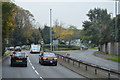
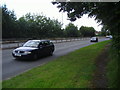
3
Kingston Bypass eastbound, Hinchley Wood
Image: © David Howard
Taken: 22 Jul 2007
0.14 miles
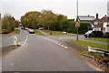
4
Houses in Southwood Gardens at the southern junction with Claygate Lane
Image: © Andrew Longton
Taken: 6 Aug 2005
0.15 miles
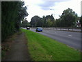
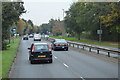
5
Kingston Bypass westbound, Hinchley Wood
Image: © David Howard
Taken: 22 Jul 2007
0.16 miles
7
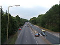
A309 from footbridge near Hinchley Wood
Looking east.
Image: © Roger Miller
Taken: 18 Aug 2005
0.20 miles
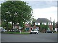
8
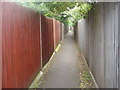
Public footpath between Claygate Avenue and Hinchley Drive
Image: © David Howard
Taken: 16 May 2011
0.22 miles