IMAGES TAKEN NEAR TO
Nisbet Drive, PRESTWICK, KA9 2TN
Introduction
This page details the photographs taken nearby to Nisbet Drive, KA9 2TN by members of the Geograph project.
The Geograph project started in 2005 with the aim of publishing, organising and preserving representative images for every square kilometre of Great Britain, Ireland and the Isle of Man.

There are currently over 7.5m images from over14,400 individuals and you can help contribute to the project by visiting https://www.geograph.org.uk
Image Map
Images are licensed for reuse under creativecommons.org/licenses/by-sa/2.0
Notes
- Clicking on the map will re-center to the selected point.
- The higher the marker number, the further away the image location is from the centre of the postcode.
Image Listing (37 Images Found)
Images are licensed for reuse under creativecommons.org/licenses/by-sa/2.0
Image
Details
Distance
1
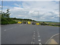
Liberator Drive
End of the road, go right up behind Asda.
Image: © Billy McCrorie
Taken: 13 Jun 2012
0.13 miles

3
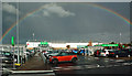
Dark Skies Over ASDA
The huge rain cloud had moved northwards after soaking Ayr and Prestwick.
Image: © Mary and Angus Hogg
Taken: 16 Oct 2016
0.15 miles
4

ASDA's Pot of Gold
If there's really a pot of gold at the end of the rainbow, there was one at the Heathfield Retail Park today.
Image: © Mary and Angus Hogg
Taken: 16 Oct 2016
0.16 miles
5
Liberator Drive
Turn right for Asda and Heathfield retail park.
Image: © Billy McCrorie
Taken: 13 Jun 2012
0.20 miles
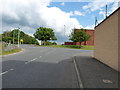
6

Liberator Drive
Retail park on the left, Asda on the right.
Image: © Billy McCrorie
Taken: 13 Jun 2012
0.20 miles
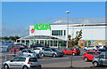

9
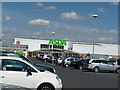
Asda Supermarket
24 hour shopping at Ayr Asda.
Image: © Billy McCrorie
Taken: 25 May 2010
0.22 miles
10
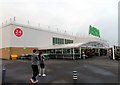
ASDA superstore on Heathfield Retail Park
Image: © Steve Daniels
Taken: 5 Jul 2019
0.22 miles