IMAGES TAKEN NEAR TO
Monkton, PRESTWICK, KA9 2SB
Introduction
This page details the photographs taken nearby to KA9 2SB by members of the Geograph project.
The Geograph project started in 2005 with the aim of publishing, organising and preserving representative images for every square kilometre of Great Britain, Ireland and the Isle of Man.

There are currently over 7.5m images from over14,400 individuals and you can help contribute to the project by visiting https://www.geograph.org.uk
Image Map
Images are licensed for reuse under creativecommons.org/licenses/by-sa/2.0
Notes
- Clicking on the map will re-center to the selected point.
- The higher the marker number, the further away the image location is from the centre of the postcode.
Image Listing (27 Images Found)
Images are licensed for reuse under creativecommons.org/licenses/by-sa/2.0
Image
Details
Distance
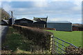
3
Farm Access Track off B739 Baird Road at Monkton
Image: © Stephen Armstrong
Taken: 25 Apr 2023
0.05 miles
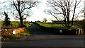
5
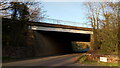
A77 Bridge over B739 Baird Road at Monkton
Image: © Stephen Armstrong
Taken: 25 Apr 2023
0.06 miles

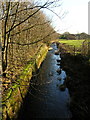
7
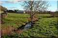
The Pow Burn At Monkton
Looking downstream on a fine November day. The burn enters the Firth of Clyde in Image
Image: © Mary and Angus Hogg
Taken: 10 Nov 2010
0.09 miles
8
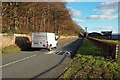
Going To Adamton
The B739 between Monkton and Adamton, viewed on a fine November afternoon.
Image: © Mary and Angus Hogg
Taken: 10 Nov 2010
0.10 miles
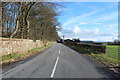
10
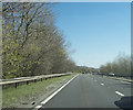
Prestwick is to the right
Invisible behind the trees to the right of the road is Prestwick Airport.
Image: © Malcolm Neal
Taken: 9 Apr 2019
0.11 miles