IMAGES TAKEN NEAR TO
Prestwick Airport, PRESTWICK, KA9 2RZ
Introduction
This page details the photographs taken nearby to Prestwick Airport, KA9 2RZ by members of the Geograph project.
The Geograph project started in 2005 with the aim of publishing, organising and preserving representative images for every square kilometre of Great Britain, Ireland and the Isle of Man.

There are currently over 7.5m images from over14,400 individuals and you can help contribute to the project by visiting https://www.geograph.org.uk
Image Map (Loading...)


Getting Data...Please wait
Leaflet Map data © OpenStreetMap
Images are licensed for reuse under creativecommons.org/licenses/by-sa/2.0
Notes
- Clicking on the map will re-center to the selected point.
- The higher the marker number, the further away the image location is from the centre of the postcode.
Image Listing (8 Images Found)
Images are licensed for reuse under creativecommons.org/licenses/by-sa/2.0
Image
Details
Distance

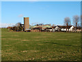
5
Whiteside farm
Looking towards HMS Gannet, in evening light, from Whiteside Drive.
Image: © M J Richardson
Taken: 24 Aug 2013
0.17 miles
6
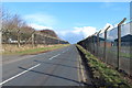
Whiteside Farm, Monkton
Viewed from B739,Tarbolton Road.
Image: © wfmillar
Taken: 9 Jan 2012
0.20 miles
7
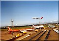
Prestwick Airport, Scotland.
A Boeing 747 Jumbo Jet taking off to cross the Atlantic Ocean to America. A Boeing 707 of Canadian Airlines is nearest the camera with another Boeing 747 Jumbo Jet parked beyond the 707.
Image: © P Flannagan
Taken: 16 Jul 1973
0.22 miles
8
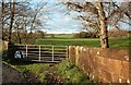
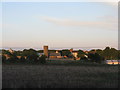
Monkton Farmland View
Looking up the Pow Burn near Monkton on a fine November afternoon.
Image: © Mary and Angus Hogg
Taken: 10 Nov 2010
0.23 miles