IMAGES TAKEN NEAR TO
Main Street, PRESTWICK, KA9 2RN
Introduction
This page details the photographs taken nearby to Main Street, KA9 2RN by members of the Geograph project.
The Geograph project started in 2005 with the aim of publishing, organising and preserving representative images for every square kilometre of Great Britain, Ireland and the Isle of Man.

There are currently over 7.5m images from over14,400 individuals and you can help contribute to the project by visiting https://www.geograph.org.uk
Image Map
Images are licensed for reuse under creativecommons.org/licenses/by-sa/2.0
Notes
- Clicking on the map will re-center to the selected point.
- The higher the marker number, the further away the image location is from the centre of the postcode.
Image Listing (75 Images Found)
Images are licensed for reuse under creativecommons.org/licenses/by-sa/2.0
Image
Details
Distance
5
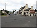
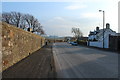
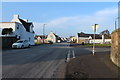
The Wheatsheaf Inn, Monkton
Looking south along Main Street, at its junction with Kilmarnock and Station Roads, with the Prestwick Airport boundary at the end of the road.
Image: © M J Richardson
Taken: 15 Jun 2010
0.02 miles
6
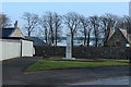
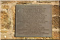
War Memorial, Monkton
Both world wars and Korea.
Image: © Billy McCrorie
Taken: 14 Feb 2017
0.02 miles
7
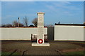
War Memorial, Monkton
Both world wars and Korea.
Image: © Billy McCrorie
Taken: 14 Feb 2017
0.02 miles
8
War Memorial, Monkton
Both world wars and Korea.
Image: © Billy McCrorie
Taken: 14 Feb 2017
0.02 miles
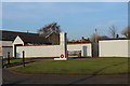
9
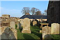
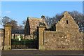
St Cuthbert's Church Graveyard, Monkton
Image: © Billy McCrorie
Taken: 14 Feb 2017
0.02 miles
10
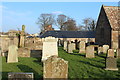
St Cuthbert's Church Graveyard, Monkton
Image: © Billy McCrorie
Taken: 14 Feb 2017
0.02 miles