IMAGES TAKEN NEAR TO
Kerrix Road, PRESTWICK, KA9 2QU
Introduction
This page details the photographs taken nearby to Kerrix Road, KA9 2QU by members of the Geograph project.
The Geograph project started in 2005 with the aim of publishing, organising and preserving representative images for every square kilometre of Great Britain, Ireland and the Isle of Man.

There are currently over 7.5m images from over14,400 individuals and you can help contribute to the project by visiting https://www.geograph.org.uk
Image Map
Images are licensed for reuse under creativecommons.org/licenses/by-sa/2.0
Notes
- Clicking on the map will re-center to the selected point.
- The higher the marker number, the further away the image location is from the centre of the postcode.
Image Listing (6 Images Found)
Images are licensed for reuse under creativecommons.org/licenses/by-sa/2.0
Image
Details
Distance
1
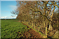
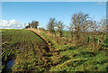
South Ayrshire Farmland
The heavy soils here provide good grazing land. The strip of trees lies along the burn and also gives some shelter to the fields.
Image: © Mary and Angus Hogg
Taken: 1 Nov 2018
0.13 miles
2
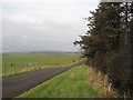
Green Fields
For February the grass is very green.
Image: © wfmillar
Taken: 4 Feb 2007
0.14 miles
4
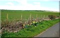
Roadside Daffodils
A splash of spring colour in this lowland grassland area.
Image: © Mary and Angus Hogg
Taken: 27 Apr 2016
0.21 miles
5
Farmland Near Monkton
The field on the left has an autumn-sown grain crop, while the one on the right is in grass.
Image: © Mary and Angus Hogg
Taken: 1 Nov 2018
0.22 miles
6
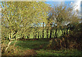
Scrubby Woodland Near Monkton
This strip of overgrown hedges and natural seedlings gives some shelter to neighbouring fields.
Image: © Mary and Angus Hogg
Taken: 1 Nov 2018
0.23 miles