IMAGES TAKEN NEAR TO
Whiteside Place, PRESTWICK, KA9 2PY
Introduction
This page details the photographs taken nearby to Whiteside Place, KA9 2PY by members of the Geograph project.
The Geograph project started in 2005 with the aim of publishing, organising and preserving representative images for every square kilometre of Great Britain, Ireland and the Isle of Man.

There are currently over 7.5m images from over14,400 individuals and you can help contribute to the project by visiting https://www.geograph.org.uk
Image Map
Images are licensed for reuse under creativecommons.org/licenses/by-sa/2.0
Notes
- Clicking on the map will re-center to the selected point.
- The higher the marker number, the further away the image location is from the centre of the postcode.
Image Listing (83 Images Found)
Images are licensed for reuse under creativecommons.org/licenses/by-sa/2.0
Image
Details
Distance
2
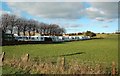
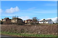
On The Edge Of Monkton
A line of caravans on the edge of Monkton, near Prestwick.
Image: © Mary and Angus Hogg
Taken: 10 Nov 2010
0.07 miles
4
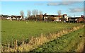
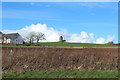
Monkton Farmland
Farmland on the edge of Monkton, close to Prestwick Airport.
Image: © Mary and Angus Hogg
Taken: 10 Nov 2010
0.10 miles
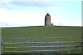
7
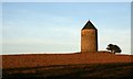
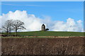
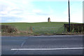
Monkton Windmill
The former windmill, a site of historical importance, tops of hill in a ploughed field.
Image: © Mick Garratt
Taken: 4 Apr 2007
0.13 miles