IMAGES TAKEN NEAR TO
Kirklandholm, PRESTWICK, KA9 2EF
Introduction
This page details the photographs taken nearby to Kirklandholm, KA9 2EF by members of the Geograph project.
The Geograph project started in 2005 with the aim of publishing, organising and preserving representative images for every square kilometre of Great Britain, Ireland and the Isle of Man.

There are currently over 7.5m images from over14,400 individuals and you can help contribute to the project by visiting https://www.geograph.org.uk
Image Map
Images are licensed for reuse under creativecommons.org/licenses/by-sa/2.0
Notes
- Clicking on the map will re-center to the selected point.
- The higher the marker number, the further away the image location is from the centre of the postcode.
Image Listing (5 Images Found)
Images are licensed for reuse under creativecommons.org/licenses/by-sa/2.0
Image
Details
Distance
1
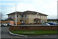
Prestwick Golf Club
The clubhouse of Prestwick St Cuthbert Golf Club, founded in 1899.
Image: © Mary and Angus Hogg
Taken: 7 Feb 2008
0.15 miles
2
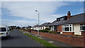
Crawford Avenue, Prestwick
Houses in Crawford Avenue.
Image: © Peter Mackenzie
Taken: 11 Sep 2018
0.20 miles
3
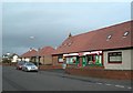
The Spar Shop
The Spar shop on Adamton Road South, in Prestwick. The shop blends well with the surrounding residential properties.
Image: © Mary and Angus Hogg
Taken: 7 Feb 2008
0.21 miles
4
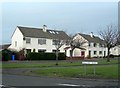
Biggart Road, Prestwick
Viewed on a cool February day.
Image: © Mary and Angus Hogg
Taken: 7 Feb 2008
0.23 miles
5
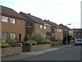
Hawthorn Avenue, Prestwick
A residential street in Prestwick.
Image: © Mary and Angus Hogg
Taken: 7 Feb 2008
0.23 miles