IMAGES TAKEN NEAR TO
Craigpark Avenue, PRESTWICK, KA9 2BG
Introduction
This page details the photographs taken nearby to Craigpark Avenue, KA9 2BG by members of the Geograph project.
The Geograph project started in 2005 with the aim of publishing, organising and preserving representative images for every square kilometre of Great Britain, Ireland and the Isle of Man.

There are currently over 7.5m images from over14,400 individuals and you can help contribute to the project by visiting https://www.geograph.org.uk
Image Map
Images are licensed for reuse under creativecommons.org/licenses/by-sa/2.0
Notes
- Clicking on the map will re-center to the selected point.
- The higher the marker number, the further away the image location is from the centre of the postcode.
Image Listing (45 Images Found)
Images are licensed for reuse under creativecommons.org/licenses/by-sa/2.0
Image
Details
Distance
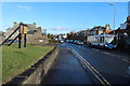
2
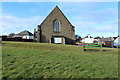
Garden at Crandleyhill Road, Prestwick
Image: © Billy McCrorie
Taken: 7 Feb 2014
0.09 miles
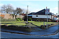
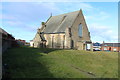
5
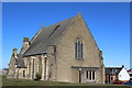
St Ninian's Episcopal Church, Prestwick
Viewed from Ayr Road
Image: © Leslie Barrie
Taken: 21 Mar 2015
0.11 miles
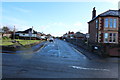
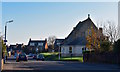
7
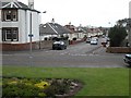
Maryborough Avenue
Note the unusual spelling of Maryborough. Residential street in Prestwick seen from Bruce's Well Image
Image: © Richard Webb
Taken: 9 Sep 2009
0.12 miles
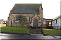
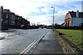
10
Maryborough Road, Prestwick, South Ayrshire
Maryborough Road lies just off Ayr Road and ends at Prestwick Promenade.
Image: © Mark S
Taken: 17 Nov 2018
0.12 miles