IMAGES TAKEN NEAR TO
Afton Avenue, PRESTWICK, KA9 2AG
Introduction
This page details the photographs taken nearby to Afton Avenue, KA9 2AG by members of the Geograph project.
The Geograph project started in 2005 with the aim of publishing, organising and preserving representative images for every square kilometre of Great Britain, Ireland and the Isle of Man.

There are currently over 7.5m images from over14,400 individuals and you can help contribute to the project by visiting https://www.geograph.org.uk
Image Map
Images are licensed for reuse under creativecommons.org/licenses/by-sa/2.0
Notes
- Clicking on the map will re-center to the selected point.
- The higher the marker number, the further away the image location is from the centre of the postcode.
Image Listing (40 Images Found)
Images are licensed for reuse under creativecommons.org/licenses/by-sa/2.0
Image
Details
Distance
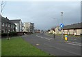
1
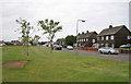
Afton Avenue, Prestwick
To the east of the road is a large recreational grassed area which is maintained in neatly mown condition, but has no play equipment and is not marked out for any sports.
Image: © Richard Dorrell
Taken: 25 Jun 2013
0.02 miles
2
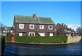
Doon Avenue, Prestwick
Timber-built housing at the junction of Doon Avenue and Afton Avenue.
Image: © Mary and Angus Hogg
Taken: 24 Jan 2008
0.04 miles
3
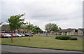
Residential area, Prestwick
The photographer is standing in Waterloo Road, looking north towards Afton Avenue.
Image: © Richard Dorrell
Taken: 25 Jun 2013
0.07 miles
5
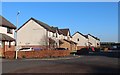
Adamton Road South
Looking northwards along Adamton Road South. This view shows different styles of local authority housing - terraced houses and flats on the left, old people's houses on the right. Kingcase Primary School, in the same square, is in the background.
Image: © Mary and Angus Hogg
Taken: 7 Feb 2008
0.13 miles
6
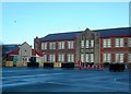
Heathfield Primary School
Some interesting play equipment in the front playground of this local authority school.
Image: © Mary and Angus Hogg
Taken: 24 Jan 2008
0.13 miles
7
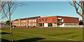
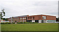
Heathfield Primary School
A modern extension has been added to this busy school. For a previous view, see Image
Image: © Mary and Angus Hogg
Taken: 30 Nov 2017
0.13 miles
8
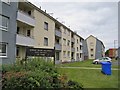
Flats in Arran Park
Viewed looking west from Adamton Road South.
Image: © Richard Dorrell
Taken: 25 Jun 2013
0.15 miles
9
Heathfield School, Ayr
The original part of the school was built in 1931, with an extension which opened in January 2012. The school has some 650 pupils on roll, aged 4 - 11.
Image: © Richard Dorrell
Taken: 25 Jun 2013
0.15 miles
10
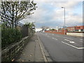
Heathfield Road
Heading in the direction of the Prestwick rd.
Image: © Billy McCrorie
Taken: 27 Oct 2011
0.15 miles