IMAGES TAKEN NEAR TO
Monkton, PRESTWICK, KA9 1UH
Introduction
This page details the photographs taken nearby to KA9 1UH by members of the Geograph project.
The Geograph project started in 2005 with the aim of publishing, organising and preserving representative images for every square kilometre of Great Britain, Ireland and the Isle of Man.

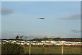
There are currently over 7.5m images from over14,400 individuals and you can help contribute to the project by visiting https://www.geograph.org.uk
Image Map
Images are licensed for reuse under creativecommons.org/licenses/by-sa/2.0
Notes
- Clicking on the map will re-center to the selected point.
- The higher the marker number, the further away the image location is from the centre of the postcode.
Image Listing (41 Images Found)
Images are licensed for reuse under creativecommons.org/licenses/by-sa/2.0
Image
Details
Distance
1
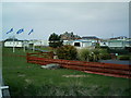
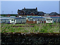
Holiday Park
This Holiday Park is situated almost directly below the approach from the sea to the main runway at Prestwick Airport, so it would be ideal for any plane spotters, but pretty noisy for everyone else.
Image: © Ian Rainey
Taken: 21 Apr 2006
0.03 miles
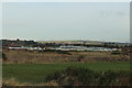
4
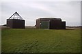
Scottish Water St Andrews sewage pumping station
Image: © Gordon Brown
Taken: 21 Jan 2010
0.07 miles
5
Prestwick Holiday Park
With plane coming into land at Glasgow Prestwick Airport.
Image: © Billy McCrorie
Taken: 29 Dec 2016
0.08 miles
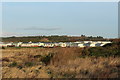
6
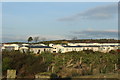
Prestwick Holiday Park
Viewed across the railway line from the A79 road.
Image: © Thomas Nugent
Taken: 9 May 2011
0.08 miles
8
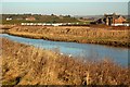
Across The Pow Burn
Looking across the Pow Burn towards Prestwick Holiday Park. The tide was still coming in when this shot was taken.
Image: © Mary and Angus Hogg
Taken: 29 Dec 2008
0.09 miles
10
Ayrshire Coastal Path
With kissing gate and waymarker.
Image: © Billy McCrorie
Taken: 29 Dec 2016
0.13 miles