IMAGES TAKEN NEAR TO
Burgh Road, PRESTWICK, KA9 1QU
Introduction
This page details the photographs taken nearby to Burgh Road, KA9 1QU by members of the Geograph project.
The Geograph project started in 2005 with the aim of publishing, organising and preserving representative images for every square kilometre of Great Britain, Ireland and the Isle of Man.

There are currently over 7.5m images from over14,400 individuals and you can help contribute to the project by visiting https://www.geograph.org.uk
Image Map
Images are licensed for reuse under creativecommons.org/licenses/by-sa/2.0
Notes
- Clicking on the map will re-center to the selected point.
- The higher the marker number, the further away the image location is from the centre of the postcode.
Image Listing (240 Images Found)
Images are licensed for reuse under creativecommons.org/licenses/by-sa/2.0
Image
Details
Distance
1
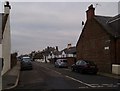
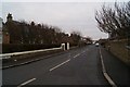
Allanvale Road
Looking north from Burgh Road.
Image: © Thomas Nugent
Taken: 25 Jan 2010
0.01 miles
2
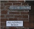
Signs on Allanvale Road
At the junction of Burgh Road.
Image: © Thomas Nugent
Taken: 25 Jan 2010
0.01 miles
4
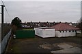
Howie Bowling Club
Viewed from the footbridge on Bridge Street.
Image: © Thomas Nugent
Taken: 25 Jan 2010
0.05 miles
5
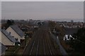
The line to Ayr
Viewed from the footbridge on Bridge Street.
Image: © Thomas Nugent
Taken: 25 Jan 2010
0.05 miles
6
Bridge Street
Looking towards the beach from the railway footbridge.
Image: © Thomas Nugent
Taken: 25 Jan 2010
0.06 miles
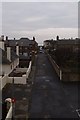
7
Bridge Street
Looking towards the railway bridge from Allanvale Street.
Image: © Thomas Nugent
Taken: 25 Jan 2010
0.07 miles
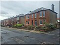
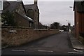
8
Marina Road
Looking south from Burgh Road.
Image: © Thomas Nugent
Taken: 25 Jan 2010
0.08 miles
9
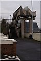
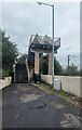
Railway footbridge
A concrete structure on Bridge Street.
Image: © Thomas Nugent
Taken: 25 Jan 2010
0.08 miles