IMAGES TAKEN NEAR TO
Bank Street, PRESTWICK, KA9 1PT
Introduction
This page details the photographs taken nearby to Bank Street, KA9 1PT by members of the Geograph project.
The Geograph project started in 2005 with the aim of publishing, organising and preserving representative images for every square kilometre of Great Britain, Ireland and the Isle of Man.

There are currently over 7.5m images from over14,400 individuals and you can help contribute to the project by visiting https://www.geograph.org.uk
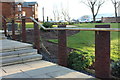
Image Map
Images are licensed for reuse under creativecommons.org/licenses/by-sa/2.0
Notes
- Clicking on the map will re-center to the selected point.
- The higher the marker number, the further away the image location is from the centre of the postcode.
Image Listing (147 Images Found)
Images are licensed for reuse under creativecommons.org/licenses/by-sa/2.0
Image
Details
Distance
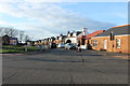
1
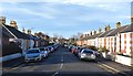
Bank Street, Prestwick, South Ayrshire
Dead-end street just off Midton Road in Prestwick. The Ayrshire Coast Line runs past the end of the street.
Image: © Mark S
Taken: 8 Feb 2020
0.01 miles
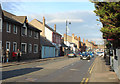
3
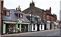
Prestwick Main Street, South Ayrshire
Costley’s Patisserie and the Golf Inn.
Image: © Mark S
Taken: 13 Jul 2019
0.07 miles
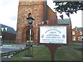
4
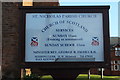
St Nicholas Parish Church Sign, Prestwick
Image: © Billy McCrorie
Taken: 29 Dec 2016
0.07 miles
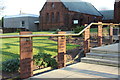
9
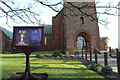
St Nicholas Parish Church, Prestwick
Image: © Billy McCrorie
Taken: 29 Dec 2016
0.08 miles
10
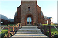
St Nicholas Parish Church, Prestwick
Image: © Billy McCrorie
Taken: 29 Dec 2016
0.08 miles