IMAGES TAKEN NEAR TO
Sherwood Road, PRESTWICK, KA9 1EY
Introduction
This page details the photographs taken nearby to Sherwood Road, KA9 1EY by members of the Geograph project.
The Geograph project started in 2005 with the aim of publishing, organising and preserving representative images for every square kilometre of Great Britain, Ireland and the Isle of Man.

There are currently over 7.5m images from over14,400 individuals and you can help contribute to the project by visiting https://www.geograph.org.uk
Image Map
Images are licensed for reuse under creativecommons.org/licenses/by-sa/2.0
Notes
- Clicking on the map will re-center to the selected point.
- The higher the marker number, the further away the image location is from the centre of the postcode.
Image Listing (17 Images Found)
Images are licensed for reuse under creativecommons.org/licenses/by-sa/2.0
Image
Details
Distance
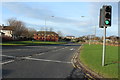
1
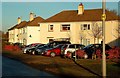
Outdale Avenue, Prestwick
Local authority houses near the former Glenburn Colliery, now an industrial estate. Viewed in late-afternoon November sunshine.
Image: © Mary and Angus Hogg
Taken: 23 Nov 2010
0.12 miles
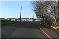
2
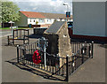
Glenburn Miners Cairn
This cairn marks the site of the former miners' rows of Glenburn Pit, in Prestwick. Other than the Glenburn Miners Welfare Amateur Football Club, there's nothing else left to show that a coal mine ever existed here. The inscription reads:
IN MEMORY OF
GLENBURN MINER’S ROWS
1914 – 1971
DEDICATED BY
MINERS FAMILIES AND LOCAL ORGANISATIONS
THE SWORD OF JUSTICE IN THEIR HANDS
TO SHIELD AND GUARD THEIR NATIVE LAND.
SEE HERE ON THE SCROLL THEIR NAMES
WHO DIED ON LAND AND SEA
WHO FOUGHT AND DIED IN FREEDOM’S CAUSE.
THIS CAIRN WAS ERECTED BY
SOUTH AYRSHIRE COUNCIL
TO COMMEMORATE THE SITE OF THE
“GLENBURN ROWS”
AND TO THE MEN AND WOMEN
WHO LIVED IN THIS COMMUNITY
BETWEEN 1912 AND 1971.
ALSO DEDICATD TO THE MEMORY OF
THE COLLIERS WHO LOST THEIR LIVES
IN GLENBURN PIT.
THOSE KILLED IN ACTION IN WORLD WAR 1
NAMES LISTED
AT THE REQUEST OF THE LATE
MR. JACKIE YOUNG
Image: © Mary and Angus Hogg
Taken: 24 Apr 2014
0.13 miles
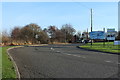
3
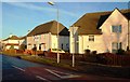
Outdale Avenue, Prestwick
Viewed at the junction with Marchburn Avenue, these local authority houses are near the former Glenburn Colliery, now an industrial estate.
Image: © Mary and Angus Hogg
Taken: 23 Nov 2010
0.17 miles
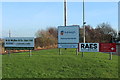
6
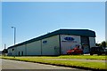
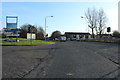
Asbestos Analytical Services - Prestwick
Analysis and disposal of unwanted asbestos products
Image: © Ian Rainey
Taken: 27 Jun 2019
0.22 miles