IMAGES TAKEN NEAR TO
Hamilton Way, PRESTWICK, KA9 1BJ
Introduction
This page details the photographs taken nearby to Hamilton Way, KA9 1BJ by members of the Geograph project.
The Geograph project started in 2005 with the aim of publishing, organising and preserving representative images for every square kilometre of Great Britain, Ireland and the Isle of Man.

There are currently over 7.5m images from over14,400 individuals and you can help contribute to the project by visiting https://www.geograph.org.uk
Image Map
Images are licensed for reuse under creativecommons.org/licenses/by-sa/2.0
Notes
- Clicking on the map will re-center to the selected point.
- The higher the marker number, the further away the image location is from the centre of the postcode.
Image Listing (154 Images Found)
Images are licensed for reuse under creativecommons.org/licenses/by-sa/2.0
Image
Details
Distance
2
Capper View
Forms part of National Cycle Network Route 75.
Image: © Thomas Nugent
Taken: 27 Jan 2009
0.04 miles
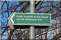
3
Public Footpath to Kirk Street, Prestwick
Path is Scottish Rights of Way and Access.
Image: © Billy McCrorie
Taken: 7 Feb 2014
0.06 miles
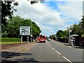
5
Public Footpath Sign, Prestwick
By the Scottish Rights of Way and Access Society.
Image: © Billy McCrorie
Taken: 7 Feb 2014
0.07 miles
9
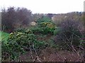
Disused railway line
A well overgrown line, running parallel with the A79 near Prestwick Airport.
Image: © Thomas Nugent
Taken: 27 Jan 2009
0.08 miles
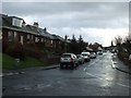
10
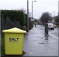
Salt bin
On Monkton road, looking towards the town centre.
Image: © Thomas Nugent
Taken: 27 Jan 2009
0.08 miles