IMAGES TAKEN NEAR TO
Victoria Crescent, AYR, KA8 9TL
Introduction
This page details the photographs taken nearby to Victoria Crescent, KA8 9TL by members of the Geograph project.
The Geograph project started in 2005 with the aim of publishing, organising and preserving representative images for every square kilometre of Great Britain, Ireland and the Isle of Man.

There are currently over 7.5m images from over14,400 individuals and you can help contribute to the project by visiting https://www.geograph.org.uk
Image Map
Images are licensed for reuse under creativecommons.org/licenses/by-sa/2.0
Notes
- Clicking on the map will re-center to the selected point.
- The higher the marker number, the further away the image location is from the centre of the postcode.
Image Listing (26 Images Found)
Images are licensed for reuse under creativecommons.org/licenses/by-sa/2.0
Image
Details
Distance
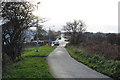
1
Bowling Club, Whitletts
Entrance from Glenmuir Place.
Image: © Billy McCrorie
Taken: 8 Nov 2012
0.14 miles
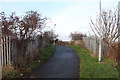
2
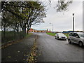
Glenmuir Place, Whitletts
Heading for the Sports Ground.
Image: © Billy McCrorie
Taken: 8 Nov 2012
0.14 miles
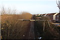
3
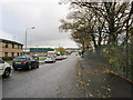
Glenmuir Place, Whitletts
Leading towards James Brown Avenue.
Image: © Billy McCrorie
Taken: 8 Nov 2012
0.15 miles
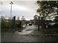
4
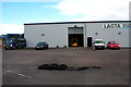
Jim Mair Forklift Truck Training Facility - Ayr
Image: © Ian Rainey
Taken: 1 Aug 2017
0.17 miles
6
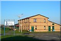
North Ayr Health Centre
North Ayr Health Centre, located in Glenmuir Place in the Whitletts area of north Ayr. Viewed on a bright Saturday morning in January.
Image: © Mary and Angus Hogg
Taken: 3 Jan 2008
0.18 miles
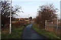
9
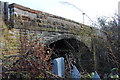
Bridge over Railway, Whitletts
Footpath bridge.
Image: © Billy McCrorie
Taken: 8 Dec 2016
0.20 miles