IMAGES TAKEN NEAR TO
Low Road, AYR, KA8 9SD
Introduction
This page details the photographs taken nearby to Low Road, KA8 9SD by members of the Geograph project.
The Geograph project started in 2005 with the aim of publishing, organising and preserving representative images for every square kilometre of Great Britain, Ireland and the Isle of Man.

There are currently over 7.5m images from over14,400 individuals and you can help contribute to the project by visiting https://www.geograph.org.uk
Image Map
Images are licensed for reuse under creativecommons.org/licenses/by-sa/2.0
Notes
- Clicking on the map will re-center to the selected point.
- The higher the marker number, the further away the image location is from the centre of the postcode.
Image Listing (161 Images Found)
Images are licensed for reuse under creativecommons.org/licenses/by-sa/2.0
Image
Details
Distance
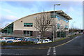
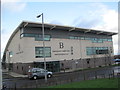
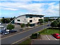
1
Fitness Centre
Bannatyne's health centre
Image: © Billy McCrorie
Taken: 19 Jun 2010
0.02 miles
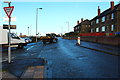
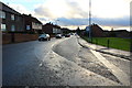
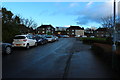
5
Low Road, Ayr
Council houses in Low Road, on the northern edge of Ayr. Some have been purchased by tenants, under the Right-to-Buy scheme.
Image: © Mary and Angus Hogg
Taken: 20 May 2009
0.03 miles
6
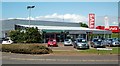
Cars For Sale
The Skoda dealer's showroom in Old Bridge Road, in north Ayr.
Image: © Mary and Angus Hogg
Taken: 20 May 2009
0.04 miles
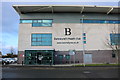
8
Bannatyne's Health Club on Highfield Drive
Image: © Steve Daniels
Taken: 6 Jul 2019
0.04 miles