IMAGES TAKEN NEAR TO
McColgan Place, AYR, KA8 9PU
Introduction
This page details the photographs taken nearby to McColgan Place, KA8 9PU by members of the Geograph project.
The Geograph project started in 2005 with the aim of publishing, organising and preserving representative images for every square kilometre of Great Britain, Ireland and the Isle of Man.

There are currently over 7.5m images from over14,400 individuals and you can help contribute to the project by visiting https://www.geograph.org.uk
Image Map
Images are licensed for reuse under creativecommons.org/licenses/by-sa/2.0
Notes
- Clicking on the map will re-center to the selected point.
- The higher the marker number, the further away the image location is from the centre of the postcode.
Image Listing (19 Images Found)
Images are licensed for reuse under creativecommons.org/licenses/by-sa/2.0
Image
Details
Distance
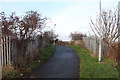
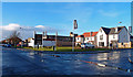
1
New Housing, Heathfield
The latest batch at Kings Park estate.
Image: © wfmillar
Taken: 23 Jan 2012
0.05 miles
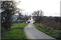
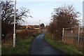
2
New Housing, Heathfield
Seaforth Road to the left. The building behind the wooden fence is the Ayr TA Centre. B Company, 52nd Lowland, 6th Battalion, The Royal Regiment of Scotland - InfantryTA is stationed here.
Image: © wfmillar
Taken: 23 Jan 2012
0.09 miles
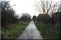

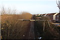
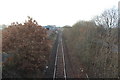
7
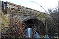
Bridge over Railway, Whitletts
Footpath bridge.
Image: © Billy McCrorie
Taken: 8 Dec 2016
0.18 miles