IMAGES TAKEN NEAR TO
Oswald Place, AYR, KA8 8PJ
Introduction
This page details the photographs taken nearby to Oswald Place, KA8 8PJ by members of the Geograph project.
The Geograph project started in 2005 with the aim of publishing, organising and preserving representative images for every square kilometre of Great Britain, Ireland and the Isle of Man.

There are currently over 7.5m images from over14,400 individuals and you can help contribute to the project by visiting https://www.geograph.org.uk
Image Map
Images are licensed for reuse under creativecommons.org/licenses/by-sa/2.0
Notes
- Clicking on the map will re-center to the selected point.
- The higher the marker number, the further away the image location is from the centre of the postcode.
Image Listing (72 Images Found)
Images are licensed for reuse under creativecommons.org/licenses/by-sa/2.0
Image
Details
Distance
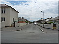
2
Marchfield Quadrant
From Oswald road.
Image: © Billy McCrorie
Taken: 13 Jun 2012
0.05 miles
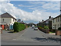
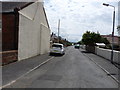
7
Woodfield Crescent
From Oswald Road.
Image: © Billy McCrorie
Taken: 13 Jun 2012
0.10 miles
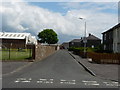
8
Marchfield Quadrant
From Marchfield road.
Image: © Billy McCrorie
Taken: 13 Jun 2012
0.10 miles
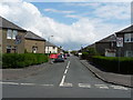
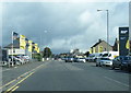
9
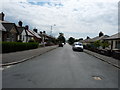
Oswald Road
From the junction with Marchfield road in the direction of Ayr.
Image: © Billy McCrorie
Taken: 13 Jun 2012
0.11 miles
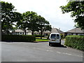
10
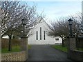
The Baptist Church
The entrance to the Baptist Church on Prestwick Road.
Image: © Mary and Angus Hogg
Taken: 7 Feb 2008
0.11 miles