IMAGES TAKEN NEAR TO
Oswald Road, AYR, KA8 8NY
Introduction
This page details the photographs taken nearby to Oswald Road, KA8 8NY by members of the Geograph project.
The Geograph project started in 2005 with the aim of publishing, organising and preserving representative images for every square kilometre of Great Britain, Ireland and the Isle of Man.

There are currently over 7.5m images from over14,400 individuals and you can help contribute to the project by visiting https://www.geograph.org.uk
Image Map
Images are licensed for reuse under creativecommons.org/licenses/by-sa/2.0
Notes
- Clicking on the map will re-center to the selected point.
- The higher the marker number, the further away the image location is from the centre of the postcode.
Image Listing (70 Images Found)
Images are licensed for reuse under creativecommons.org/licenses/by-sa/2.0
Image
Details
Distance
1
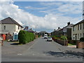
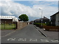
Marchfield Quadrant
From Oswald road.
Image: © Billy McCrorie
Taken: 13 Jun 2012
0.04 miles
5
Woodfield Crescent
From Oswald Road.
Image: © Billy McCrorie
Taken: 13 Jun 2012
0.08 miles
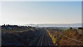
6
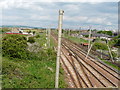
Railway Line
Ayr to Glasgow main line.
Image: © Billy McCrorie
Taken: 13 Jun 2012
0.09 miles
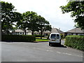
7
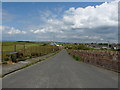
Bellrock Road
With Prestwick St Nicholas golf course on the left.
Image: © Billy McCrorie
Taken: 13 Jun 2012
0.10 miles
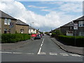
8
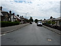
Oswald Road
From the junction with Marchfield road in the direction of Ayr.
Image: © Billy McCrorie
Taken: 13 Jun 2012
0.11 miles
9
Ayrshire Coast Line, Prestwick, South Ayrshire
From Maryborough Road in Prestwick we are looking along the Ayrshire Coast Line, with the town of Ayr in the distance.
Image: © Mark S
Taken: 17 Nov 2018
0.11 miles
10
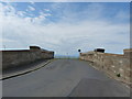
Bellrock Road
Bridge over the main Ayr to Glasgow railway line.
Image: © Billy McCrorie
Taken: 13 Jun 2012
0.12 miles