IMAGES TAKEN NEAR TO
Oswald Court, AYR, KA8 8NL
Introduction
This page details the photographs taken nearby to Oswald Court, KA8 8NL by members of the Geograph project.
The Geograph project started in 2005 with the aim of publishing, organising and preserving representative images for every square kilometre of Great Britain, Ireland and the Isle of Man.

There are currently over 7.5m images from over14,400 individuals and you can help contribute to the project by visiting https://www.geograph.org.uk
Image Map
Images are licensed for reuse under creativecommons.org/licenses/by-sa/2.0
Notes
- Clicking on the map will re-center to the selected point.
- The higher the marker number, the further away the image location is from the centre of the postcode.
Image Listing (76 Images Found)
Images are licensed for reuse under creativecommons.org/licenses/by-sa/2.0
Image
Details
Distance
1
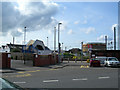
Newton-on-Ayr Station
Looking west, with the old gasometer in the background.
Image: © Mary and Angus Hogg
Taken: 22 Sep 2006
0.08 miles
2
Newton-on-Ayr
Looking ENE from the bridge beside the old gasometer, showing St James Parish Church behind Newton-on-Ayr station.
Image: © Mary and Angus Hogg
Taken: 22 Sep 2006
0.08 miles
3
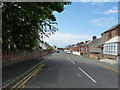
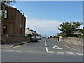
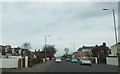
Falkland Road
From the Prestwick road.
Image: © Billy McCrorie
Taken: 13 Jun 2012
0.09 miles
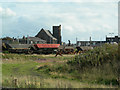
4
Old fertiliser factory
The derelict Scottish Agricultural Industries Limited Ayr Fertiliser Works building, by the railway line just north of Newton on Ayr station. Viewed from an Ayr bound train.
Image: © Thomas Nugent
Taken: 9 Apr 2013
0.10 miles
5
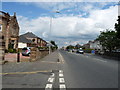
Lansdowne Road
From the junction with the Prestwick road.
Image: © Billy McCrorie
Taken: 13 Jun 2012
0.10 miles
6
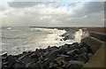
Winter on the Ayrshire Coastal Path
The tide was about half-way in when this shot was taken at Newton Shore. It's not a walk for the faint-hearted in these conditions with the risk of getting drenched by salt-water spray. For other views, see Image & Image
Image: © Mary and Angus Hogg
Taken: 12 Jan 2015
0.11 miles
7
Prestwick Road
From the junction with Falkland road.
Image: © Billy McCrorie
Taken: 13 Jun 2012
0.12 miles
8
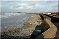
The Ayrshire Coastal Path At Newton Shore
The coastal path guide book warns walkers to expect waves breaking over this sea wall when on-shore winds are combined with high tides. Just like this - Image
Image: © Mary and Angus Hogg
Taken: 24 Oct 2008
0.12 miles
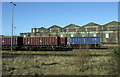
10
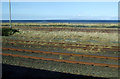
Railway sidings
Coal train sidings, just north of Newton on Ayr station. Viewed from an Ayr bound train. The Firth of Clyde can be seen beyond.
Image: © Thomas Nugent
Taken: 9 Apr 2013
0.12 miles