IMAGES TAKEN NEAR TO
Argyle Park, AYR, KA8 8JP
Introduction
This page details the photographs taken nearby to Argyle Park, KA8 8JP by members of the Geograph project.
The Geograph project started in 2005 with the aim of publishing, organising and preserving representative images for every square kilometre of Great Britain, Ireland and the Isle of Man.

There are currently over 7.5m images from over14,400 individuals and you can help contribute to the project by visiting https://www.geograph.org.uk
Image Map
Images are licensed for reuse under creativecommons.org/licenses/by-sa/2.0
Notes
- Clicking on the map will re-center to the selected point.
- The higher the marker number, the further away the image location is from the centre of the postcode.
Image Listing (205 Images Found)
Images are licensed for reuse under creativecommons.org/licenses/by-sa/2.0
Image
Details
Distance
2

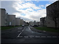
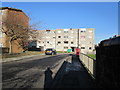
Viewfield Court
From Viewfield Road.
Image: © Billy McCrorie
Taken: 15 Feb 2012
0.06 miles
3
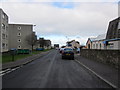
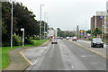
Viewfield Road
From the junction with Russell Drive looking towards the Prestwick Road.
Image: © Billy McCrorie
Taken: 15 Feb 2012
0.06 miles

5
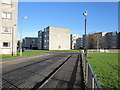
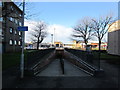
Limonds Wynd
Approaching Russell Drive.
Image: © Billy McCrorie
Taken: 10 Jan 2013
0.08 miles
6
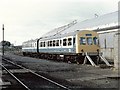
Ayr Railway Depot
Units 51236 & 53183 stand in the depot sidings
Image: © Dave Hitchborne
Taken: 2 Sep 1989
0.09 miles
10
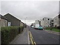
Viewfield Road
From the junction with Allison Street/Prestwick Road.
Image: © Billy McCrorie
Taken: 15 Feb 2012
0.11 miles