IMAGES TAKEN NEAR TO
New Road, AYR, KA8 8EX
Introduction
This page details the photographs taken nearby to New Road, KA8 8EX by members of the Geograph project.
The Geograph project started in 2005 with the aim of publishing, organising and preserving representative images for every square kilometre of Great Britain, Ireland and the Isle of Man.

There are currently over 7.5m images from over14,400 individuals and you can help contribute to the project by visiting https://www.geograph.org.uk
Image Map
Images are licensed for reuse under creativecommons.org/licenses/by-sa/2.0
Notes
- Clicking on the map will re-center to the selected point.
- The higher the marker number, the further away the image location is from the centre of the postcode.
Image Listing (298 Images Found)
Images are licensed for reuse under creativecommons.org/licenses/by-sa/2.0
Image
Details
Distance

2

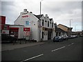
The Drouthy Bar
Located on New Road.
Image: © Billy McCrorie
Taken: 12 Jan 2012
0.02 miles
4
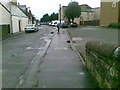
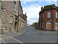
Peebles Street, Newton -On-Ayr
The junction of Peebles Street and New Road, in Newton-on-Ayr. Viewed on a fine day in mid-May.
Image: © Mary and Angus Hogg
Taken: 20 May 2009
0.03 miles
5
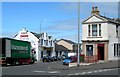
McConechy's Tyres, Peebles Street, Ayr
Image: © Billy McCrorie
Taken: 4 Jun 2017
0.03 miles
6
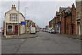
Peebles Street
Mixed use street near the port.
Image: © Richard Webb
Taken: 9 Sep 2009
0.03 miles

8
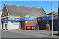
Weaver Street
From the junction with Damside.
Image: © Billy McCrorie
Taken: 13 Jun 2012
0.04 miles
10
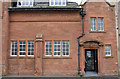
The Salvation Army Citadel, Ayr
A Category C Listed Building.
Image: © Billy McCrorie
Taken: 8 Oct 2019
0.04 miles