IMAGES TAKEN NEAR TO
Dalmilling Road, AYR, KA8 0PS
Introduction
This page details the photographs taken nearby to Dalmilling Road, KA8 0PS by members of the Geograph project.
The Geograph project started in 2005 with the aim of publishing, organising and preserving representative images for every square kilometre of Great Britain, Ireland and the Isle of Man.

There are currently over 7.5m images from over14,400 individuals and you can help contribute to the project by visiting https://www.geograph.org.uk
Image Map
Images are licensed for reuse under creativecommons.org/licenses/by-sa/2.0
Notes
- Clicking on the map will re-center to the selected point.
- The higher the marker number, the further away the image location is from the centre of the postcode.
Image Listing (35 Images Found)
Images are licensed for reuse under creativecommons.org/licenses/by-sa/2.0
Image
Details
Distance
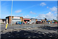
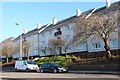
5

Shops In Main Road, Whitletts
A small shopping centre on the edge of Ayr, at the junction of Glenmuir Place and Main Road.
Image: © Mary and Angus Hogg
Taken: 20 May 2009
0.10 miles
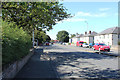
6
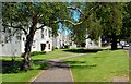
Flats At Nursery Hall
Small blocks of flats alongside Main Road, Whitletts, in the northern part of Ayr. Viewed on a fine mid-May day.
Image: © Mary and Angus Hogg
Taken: 20 May 2009
0.11 miles
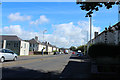
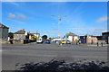
9

The Shops At Whitletts
A typical collection of businesses at an edge-of-town site at Whitletts, in north Ayr.
Image: © Mary and Angus Hogg
Taken: 20 May 2009
0.12 miles
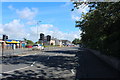
10
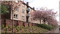
Flats, Main Road
Cherry blossom on the road into Ayr.
Image: © Richard Webb
Taken: 21 May 2013
0.12 miles