IMAGES TAKEN NEAR TO
Dalmilling Road, AYR, KA8 0PG
Introduction
This page details the photographs taken nearby to Dalmilling Road, KA8 0PG by members of the Geograph project.
The Geograph project started in 2005 with the aim of publishing, organising and preserving representative images for every square kilometre of Great Britain, Ireland and the Isle of Man.

There are currently over 7.5m images from over14,400 individuals and you can help contribute to the project by visiting https://www.geograph.org.uk
Image Map (Loading...)


Getting Data...Please wait
Leaflet Map data © OpenStreetMap
Images are licensed for reuse under creativecommons.org/licenses/by-sa/2.0
Notes
- Clicking on the map will re-center to the selected point.
- The higher the marker number, the further away the image location is from the centre of the postcode.
Image Listing (73 Images Found)
Images are licensed for reuse under creativecommons.org/licenses/by-sa/2.0
Image
Details
Distance
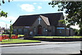
3
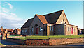
St. Quivox Parish Church, Ayr
Church of Scotland in Whitletts area of Ayr.
Image: © wfmillar
Taken: 30 Jan 2012
0.04 miles
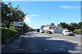
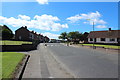
5
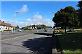
Dalmilling Road, Ayr
Approaching Thornyflat Road.
Image: © Billy McCrorie
Taken: 29 Aug 2016
0.04 miles
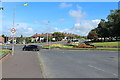
7
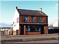
Redstone Bar, Main Road, Whitletts, Ayr
Beside the A719 dual carriageway.
Image: © wfmillar
Taken: 30 Jan 2012
0.05 miles
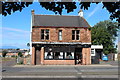
8
Main Road, Ayr
Approaching High Road (just after the traffic lights).
Image: © Billy McCrorie
Taken: 29 Aug 2016
0.06 miles