IMAGES TAKEN NEAR TO
St. Catherine's Road, AYR, KA8 0LW
Introduction
This page details the photographs taken nearby to St. Catherine's Road, KA8 0LW by members of the Geograph project.
The Geograph project started in 2005 with the aim of publishing, organising and preserving representative images for every square kilometre of Great Britain, Ireland and the Isle of Man.

There are currently over 7.5m images from over14,400 individuals and you can help contribute to the project by visiting https://www.geograph.org.uk
Image Map
Images are licensed for reuse under creativecommons.org/licenses/by-sa/2.0
Notes
- Clicking on the map will re-center to the selected point.
- The higher the marker number, the further away the image location is from the centre of the postcode.
Image Listing (9 Images Found)
Images are licensed for reuse under creativecommons.org/licenses/by-sa/2.0
Image
Details
Distance
1
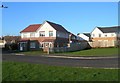
Thornyflat Place, Ayr
New houses built recently on the site of the former Thornyflat Maternity Hospital.
Image: © Mary and Angus Hogg
Taken: 3 Jan 2008
0.07 miles
2
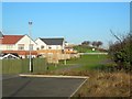
St Catherine's Place, Ayr
New housing, built recently on the site of the former Thornyflat Maternity Hospital. The tall street lamps in the background on the right show the location of the A77 Ayr by-pass.
Image: © Mary and Angus Hogg
Taken: 3 Jan 2008
0.12 miles
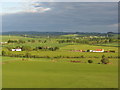
3
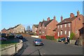
Thornyflat Drive, Ayr
Traditional council housing in Dalmilling, Ayr, viewed on a bright January morning.
Image: © Mary and Angus Hogg
Taken: 3 Jan 2008
0.14 miles
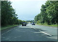
4
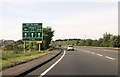
Approaching roundabout at north end of Ayr bypass
Image: © John Firth
Taken: 15 May 2014
0.15 miles
7
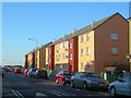
Westwood Avenue, Ayr
Recently refurbished flats in Dalmilling, located on the edge of Ayr.
Image: © Mary and Angus Hogg
Taken: 3 Jan 2008
0.23 miles
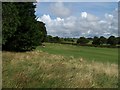
9
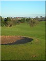
Dalmilling Golf Course
The buildings at Fulshawwood, in the next square, are in the background.
Image: © Mary and Angus Hogg
Taken: 3 Jan 2008
0.23 miles