IMAGES TAKEN NEAR TO
Elba Gardens, AYR, KA8 0DS
Introduction
This page details the photographs taken nearby to Elba Gardens, KA8 0DS by members of the Geograph project.
The Geograph project started in 2005 with the aim of publishing, organising and preserving representative images for every square kilometre of Great Britain, Ireland and the Isle of Man.

There are currently over 7.5m images from over14,400 individuals and you can help contribute to the project by visiting https://www.geograph.org.uk
Image Map
Images are licensed for reuse under creativecommons.org/licenses/by-sa/2.0
Notes
- Clicking on the map will re-center to the selected point.
- The higher the marker number, the further away the image location is from the centre of the postcode.
Image Listing (211 Images Found)
Images are licensed for reuse under creativecommons.org/licenses/by-sa/2.0
Image
Details
Distance
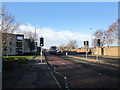
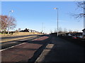
6
King Street
Heading in towards Ayr Main Street.
Image: © Billy McCrorie
Taken: 15 Feb 2012
0.07 miles
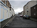
7
King Street
Russell House is on the left.
Image: © Thomas Nugent
Taken: 3 Aug 2018
0.07 miles
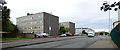
8
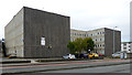
Russell House
Council offices (to let) on King Street.
Image: © Thomas Nugent
Taken: 3 Aug 2018
0.07 miles
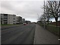
9
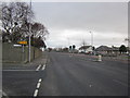
King Street
At the junction with Russell Drive, King Street leads onto Whitletts Road.
Image: © Billy McCrorie
Taken: 15 Feb 2012
0.07 miles