IMAGES TAKEN NEAR TO
Merkland Road, AYR, KA7 4UN
Introduction
This page details the photographs taken nearby to Merkland Road, KA7 4UN by members of the Geograph project.
The Geograph project started in 2005 with the aim of publishing, organising and preserving representative images for every square kilometre of Great Britain, Ireland and the Isle of Man.

There are currently over 7.5m images from over14,400 individuals and you can help contribute to the project by visiting https://www.geograph.org.uk
Image Map
Images are licensed for reuse under creativecommons.org/licenses/by-sa/2.0
Notes
- Clicking on the map will re-center to the selected point.
- The higher the marker number, the further away the image location is from the centre of the postcode.
Image Listing (20 Images Found)
Images are licensed for reuse under creativecommons.org/licenses/by-sa/2.0
Image
Details
Distance
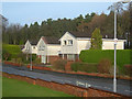
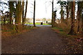
1
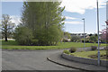
Merkland Road view
This wonderful green space is in the middle of a housing estate that has been here for about forty years.
Image: © Malcolm Neal
Taken: 7 May 2018
0.08 miles
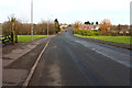
2
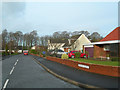
Barnford Crescent, Ayr
Private housing area to the south side of Ayr.
Image: © Mary and Angus Hogg
Taken: 19 Jan 2008
0.14 miles
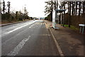
5
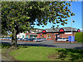
Out of town shopping
Small out of town shopping centre at Hollow Park, Maybole Road, Ayr.
Image: © Mary and Angus Hogg
Taken: 19 Sep 2006
0.16 miles
7
Barnford Crescent, Ayr
Private housing area on the south side of Ayr.
Image: © Mary and Angus Hogg
Taken: 19 Jan 2008
0.16 miles
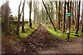
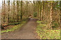
10
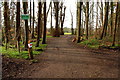
Woodland Track to the Recreation Ground
Image: © Billy McCrorie
Taken: 17 Feb 2015
0.23 miles