IMAGES TAKEN NEAR TO
Kersepark, AYR, KA7 4UD
Introduction
This page details the photographs taken nearby to Kersepark, KA7 4UD by members of the Geograph project.
The Geograph project started in 2005 with the aim of publishing, organising and preserving representative images for every square kilometre of Great Britain, Ireland and the Isle of Man.

There are currently over 7.5m images from over14,400 individuals and you can help contribute to the project by visiting https://www.geograph.org.uk
Image Map
Images are licensed for reuse under creativecommons.org/licenses/by-sa/2.0
Notes
- Clicking on the map will re-center to the selected point.
- The higher the marker number, the further away the image location is from the centre of the postcode.
Image Listing (36 Images Found)
Images are licensed for reuse under creativecommons.org/licenses/by-sa/2.0
Image
Details
Distance
4
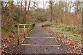
Woodland Footpath at Glengall Bridge
Image: © Billy McCrorie
Taken: 17 Feb 2015
0.08 miles
5
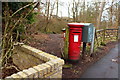
Start of Woodland Footpath at Glengall Bridge
Image: © Billy McCrorie
Taken: 17 Feb 2015
0.08 miles
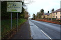
9
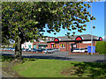
Out of town shopping
Small out of town shopping centre at Hollow Park, Maybole Road, Ayr.
Image: © Mary and Angus Hogg
Taken: 19 Sep 2006
0.09 miles