IMAGES TAKEN NEAR TO
AYR, KA7 4TP
Introduction
This page details the photographs taken nearby to KA7 4TP by members of the Geograph project.
The Geograph project started in 2005 with the aim of publishing, organising and preserving representative images for every square kilometre of Great Britain, Ireland and the Isle of Man.

There are currently over 7.5m images from over14,400 individuals and you can help contribute to the project by visiting https://www.geograph.org.uk
Image Map
Images are licensed for reuse under creativecommons.org/licenses/by-sa/2.0
Notes
- Clicking on the map will re-center to the selected point.
- The higher the marker number, the further away the image location is from the centre of the postcode.
Image Listing (6 Images Found)
Images are licensed for reuse under creativecommons.org/licenses/by-sa/2.0
Image
Details
Distance
1
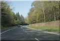
A long brick wall
The wall which borders the A77 here is the boundary of Auchendrane Castle.
Image: © Malcolm Neal
Taken: 8 Apr 2019
0.11 miles
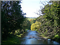
2
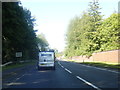
A77 River Doon sign, well before the bridge
Image: © Colin Pyle
Taken: 10 Jun 2015
0.18 miles
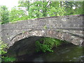
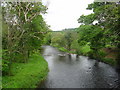
6
River Doon
Viewed from the new Monkwood Bridge, to the north of Minishant
Image: © Mary and Angus Hogg
Taken: 9 Oct 2006
0.21 miles