IMAGES TAKEN NEAR TO
Shanter Place, AYR, KA7 4RD
Introduction
This page details the photographs taken nearby to Shanter Place, KA7 4RD by members of the Geograph project.
The Geograph project started in 2005 with the aim of publishing, organising and preserving representative images for every square kilometre of Great Britain, Ireland and the Isle of Man.

There are currently over 7.5m images from over14,400 individuals and you can help contribute to the project by visiting https://www.geograph.org.uk
Image Map
Images are licensed for reuse under creativecommons.org/licenses/by-sa/2.0
Notes
- Clicking on the map will re-center to the selected point.
- The higher the marker number, the further away the image location is from the centre of the postcode.
Image Listing (399 Images Found)
Images are licensed for reuse under creativecommons.org/licenses/by-sa/2.0
Image
Details
Distance
1
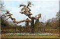
Another Old Tree
Another old, gnarled tree on the site of Cambusdoon House. Viewed in late February.
Image: © Mary and Angus Hogg
Taken: 25 Feb 2009
0.05 miles
2
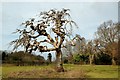
A Spooky Old Tree
An old, gnarled tree in the open space that formerly accommodated Cambusdoon House. The remmnants of the building are in the background, right of centre - an old arch, covered with ivy.
Image: © Mary and Angus Hogg
Taken: 25 Feb 2009
0.05 miles
3
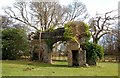
Remains of Cambusdoon House
This old arch is all that remains of Cambusdoon House, the home of the 19th century steel tycoon, James Baird. The building was burned down in 1970. (Source: "Ayrshire: Discovering A County", by Dane Love).
Image: © Mary and Angus Hogg
Taken: 25 Feb 2009
0.10 miles
4

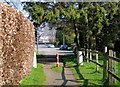
Walking The Dogs
Walkers on a popular footpath leading from Shanter Way towards the River Doon. Viewed on a fine March day.
Image: © Mary and Angus Hogg
Taken: 18 Mar 2009
0.11 miles
5
Into Shanter Way
On the very edge of the square. The first house on the right, where the blue car is parked is called Mungo's Well. This name features in Burns's famous poem, Tam O'Shanter. When Tam was riding in the dark towards Alloway Kirk, he passed some grisly spots - "And near the thorn, aboon the well, Whare Mungo's mither hang'd hersel."
Image: © Mary and Angus Hogg
Taken: 18 Mar 2009
0.11 miles
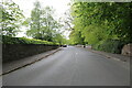
6
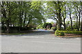
Shanter Way, Alloway
Viewed from the B7024.
Image: © Billy McCrorie
Taken: 13 May 2021
0.12 miles
8
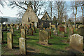
Auld Kirk Alloway
The old parish church of Alloway was built in the 16th century and was used regularly till 1691, and occasionally until the 1730s. From 1740 to at least 1752 it was used as a school building but then became ruinous. Robert Burns knew it in this condition, commemorating it in 1790 in his famous poem “Tam o’ Shanter”. In 1786, Ayr Council had the kirk building re-roofed to be a school again for several years. The graveyard remained in use till the 20th century.
(Source: Monumental Inscriptions of Carrick, Ayrshire)
Image: © Mary and Angus Hogg
Taken: 18 Mar 2009
0.13 miles
9
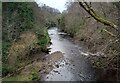
River Doon
Seen from path on old rail line
Image: © Jim Smillie
Taken: 16 Feb 2023
0.13 miles
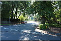
10
The B7024 at Alloway
Leading to The Robert Burns Birthplace Museum.
Image: © Billy McCrorie
Taken: 13 May 2021
0.14 miles