IMAGES TAKEN NEAR TO
Cambusdoon Drive, AYR, KA7 4PL
Introduction
This page details the photographs taken nearby to Cambusdoon Drive, KA7 4PL by members of the Geograph project.
The Geograph project started in 2005 with the aim of publishing, organising and preserving representative images for every square kilometre of Great Britain, Ireland and the Isle of Man.

There are currently over 7.5m images from over14,400 individuals and you can help contribute to the project by visiting https://www.geograph.org.uk
Image Map
Images are licensed for reuse under creativecommons.org/licenses/by-sa/2.0
Notes
- Clicking on the map will re-center to the selected point.
- The higher the marker number, the further away the image location is from the centre of the postcode.
Image Listing (274 Images Found)
Images are licensed for reuse under creativecommons.org/licenses/by-sa/2.0
Image
Details
Distance
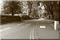
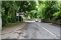
1
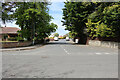
Cambusdoon Drive, Alloway
Viewed from the B7024.
Image: © Billy McCrorie
Taken: 13 May 2021
0.08 miles
2
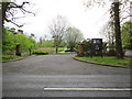
Burns Car Park
Entrance from Greenfield Avenue.
Image: © Billy McCrorie
Taken: 24 Apr 2012
0.08 miles
3
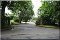
Entrance to Burns Cottage Car Park
From Greenfield Avenue, Alloway.
Image: © Billy McCrorie
Taken: 19 Jun 2020
0.09 miles
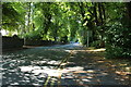
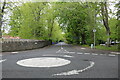
6
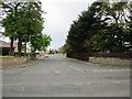
Cambusdoon Drive
From the junction with Alloway Road.
Image: © Billy McCrorie
Taken: 24 Apr 2012
0.09 miles
7
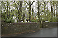
Greenfield Avenue
A very walled house and garden.
Image: © Malcolm Neal
Taken: 9 May 2018
0.09 miles
8
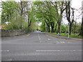
Greenfield Avenue
From the junction with the Alloway Road.
Image: © Billy McCrorie
Taken: 24 Apr 2012
0.10 miles
9
Greenfield Avenue, Alloway
From the entrance to Burns Cottage car park.
Image: © Billy McCrorie
Taken: 19 Jun 2020
0.10 miles
10
Greenfield Avenue, Alloway
From the B7024.
Image: © Billy McCrorie
Taken: 13 May 2021
0.10 miles