IMAGES TAKEN NEAR TO
Monument Road, AYR, KA7 4NG
Introduction
This page details the photographs taken nearby to Monument Road, KA7 4NG by members of the Geograph project.
The Geograph project started in 2005 with the aim of publishing, organising and preserving representative images for every square kilometre of Great Britain, Ireland and the Isle of Man.

There are currently over 7.5m images from over14,400 individuals and you can help contribute to the project by visiting https://www.geograph.org.uk
Image Map
Images are licensed for reuse under creativecommons.org/licenses/by-sa/2.0
Notes
- Clicking on the map will re-center to the selected point.
- The higher the marker number, the further away the image location is from the centre of the postcode.
Image Listing (299 Images Found)
Images are licensed for reuse under creativecommons.org/licenses/by-sa/2.0
Image
Details
Distance
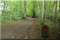
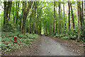
3
Remembrance Woodland Trail, Rozelle Park
Just follow the Poppy markers.
Image: © Billy McCrorie
Taken: 13 May 2021
0.05 miles
4
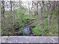
Slaphouse Burn
From the Slaphouse bridge on the Monument Road.
Image: © Billy McCrorie
Taken: 24 Apr 2012
0.06 miles
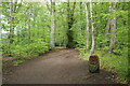
5

Woodland Track, Rozelle Park
Leading back to the Rozelle car park.
Image: © Billy McCrorie
Taken: 13 May 2021
0.07 miles
8
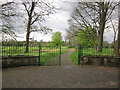
Belleisle Park
Entrance to park and golf course from the Monument road.
Image: © Billy McCrorie
Taken: 24 Apr 2012
0.09 miles
9
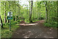
Bridle Path, Rozelle Park
Left for the Bridle path and right for the Remembrance Woodland.
Image: © Billy McCrorie
Taken: 13 May 2021
0.09 miles
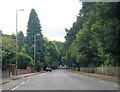
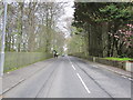
10
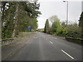
Monument Road
Heading in towards Ayr.
Image: © Billy McCrorie
Taken: 24 Apr 2012
0.10 miles