IMAGES TAKEN NEAR TO
AYR, KA7 4JL
Introduction
This page details the photographs taken nearby to KA7 4JL by members of the Geograph project.
The Geograph project started in 2005 with the aim of publishing, organising and preserving representative images for every square kilometre of Great Britain, Ireland and the Isle of Man.

There are currently over 7.5m images from over14,400 individuals and you can help contribute to the project by visiting https://www.geograph.org.uk
Image Map
Images are licensed for reuse under creativecommons.org/licenses/by-sa/2.0
Notes
- Clicking on the map will re-center to the selected point.
- The higher the marker number, the further away the image location is from the centre of the postcode.
Image Listing (4 Images Found)
Images are licensed for reuse under creativecommons.org/licenses/by-sa/2.0
Image
Details
Distance
1
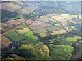
The edge of Alloway from above Sauchrie
With Newark Hill in the foreground and Burton farm near the centre.
Image: © M J Richardson
Taken: 31 Aug 2014
0.02 miles
2
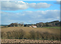
Burton Farm
Newark Castle is visible among the trees on the right.
Image: © Mary and Angus Hogg
Taken: 20 Mar 2007
0.04 miles
3
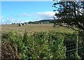
Across The Burn
Rich farmland at Burton Farm, near Ayr.
Image: © Mary and Angus Hogg
Taken: 17 Oct 2007
0.14 miles