IMAGES TAKEN NEAR TO
Browncarrick Drive, AYR, KA7 4JA
Introduction
This page details the photographs taken nearby to Browncarrick Drive, KA7 4JA by members of the Geograph project.
The Geograph project started in 2005 with the aim of publishing, organising and preserving representative images for every square kilometre of Great Britain, Ireland and the Isle of Man.

There are currently over 7.5m images from over14,400 individuals and you can help contribute to the project by visiting https://www.geograph.org.uk
Image Map
Images are licensed for reuse under creativecommons.org/licenses/by-sa/2.0
Notes
- Clicking on the map will re-center to the selected point.
- The higher the marker number, the further away the image location is from the centre of the postcode.
Image Listing (35 Images Found)
Images are licensed for reuse under creativecommons.org/licenses/by-sa/2.0
Image
Details
Distance
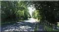
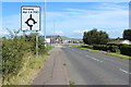
3
Brown Carrick Drive
This road takes its name from the hill in the background - Brown Carrick Hill, with the 3 radio masts.
Image: © Mary and Angus Hogg
Taken: 11 Nov 2007
0.08 miles
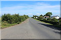
7
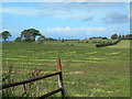
Greenan Farm, near Ayr
Rich coastal farmlands to the south of Ayr, showing Greenan Farm on the skyline
Image: © Mary and Angus Hogg
Taken: 22 Sep 2006
0.10 miles
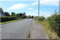
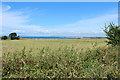
8
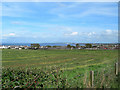
Doonfoot
Looking across Greenan Farm land towards Doonfoot, with Ayr Bay in the background.
Image: © Mary and Angus Hogg
Taken: 22 Sep 2006
0.10 miles
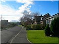
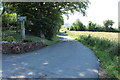
9
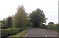
Entrance to High Greenan House from Burton Smithy
Image: © John Firth
Taken: 15 May 2014
0.10 miles