IMAGES TAKEN NEAR TO
AYR, KA7 4HX
Introduction
This page details the photographs taken nearby to KA7 4HX by members of the Geograph project.
The Geograph project started in 2005 with the aim of publishing, organising and preserving representative images for every square kilometre of Great Britain, Ireland and the Isle of Man.

There are currently over 7.5m images from over14,400 individuals and you can help contribute to the project by visiting https://www.geograph.org.uk
Image Map
Images are licensed for reuse under creativecommons.org/licenses/by-sa/2.0
Notes
- Clicking on the map will re-center to the selected point.
- The higher the marker number, the further away the image location is from the centre of the postcode.
Image Listing (40 Images Found)
Images are licensed for reuse under creativecommons.org/licenses/by-sa/2.0
Image
Details
Distance
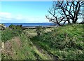
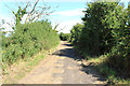
2
Cycle Route 7 at Greenan
With waymarker.
Image: © Billy McCrorie
Taken: 28 Jul 2014
0.02 miles
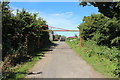
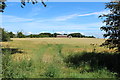
4
The Ayrshire Coastal Path
The coast to the south of Ayr is one of the most interesting and attractive parts of the Coastal Path. Viewed in mid-September.
Image: © Mary and Angus Hogg
Taken: 19 Sep 2012
0.04 miles
5
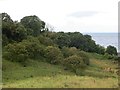
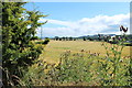
Scrub woodland, Greenan
One of several fields around Greenan that has not been put to agricultural use in recent years.
Image: © Richard Webb
Taken: 13 Aug 2014
0.05 miles
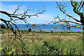
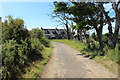
9
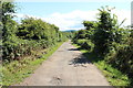
Ayrshire Coastal Path at Greenan
Also Cycle Route 7.
Image: © Billy McCrorie
Taken: 28 Jul 2014
0.06 miles