IMAGES TAKEN NEAR TO
Castle Walk, AYR, KA7 4HH
Introduction
This page details the photographs taken nearby to Castle Walk, KA7 4HH by members of the Geograph project.
The Geograph project started in 2005 with the aim of publishing, organising and preserving representative images for every square kilometre of Great Britain, Ireland and the Isle of Man.

There are currently over 7.5m images from over14,400 individuals and you can help contribute to the project by visiting https://www.geograph.org.uk
Image Map
Images are licensed for reuse under creativecommons.org/licenses/by-sa/2.0
Notes
- Clicking on the map will re-center to the selected point.
- The higher the marker number, the further away the image location is from the centre of the postcode.
Image Listing (89 Images Found)
Images are licensed for reuse under creativecommons.org/licenses/by-sa/2.0
Image
Details
Distance
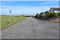
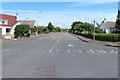
5
Earls Way meets Castle Walk, Doonfoot
Image: © Billy McCrorie
Taken: 28 Jul 2014
0.09 miles
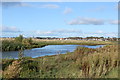
8
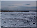
Ice on Greenan shore
Fresh water from the boggy area marked on the 1:25000 series map makes its way onto the shore and, in the low temperatures of December 2009, freezes. Arran is seen in the distance.
Image: © Alec MacKinnon
Taken: 29 Dec 2009
0.10 miles
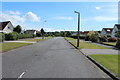
10
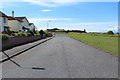
Castle Walk, Doonfoot
On the mid right is Greenan Castle.
Image: © Billy McCrorie
Taken: 28 Jul 2014
0.10 miles