IMAGES TAKEN NEAR TO
Knoweholm, AYR, KA7 4HD
Introduction
This page details the photographs taken nearby to Knoweholm, KA7 4HD by members of the Geograph project.
The Geograph project started in 2005 with the aim of publishing, organising and preserving representative images for every square kilometre of Great Britain, Ireland and the Isle of Man.

There are currently over 7.5m images from over14,400 individuals and you can help contribute to the project by visiting https://www.geograph.org.uk
Image Map
Images are licensed for reuse under creativecommons.org/licenses/by-sa/2.0
Notes
- Clicking on the map will re-center to the selected point.
- The higher the marker number, the further away the image location is from the centre of the postcode.
Image Listing (41 Images Found)
Images are licensed for reuse under creativecommons.org/licenses/by-sa/2.0
Image
Details
Distance
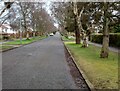
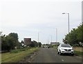
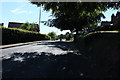
1
On the A719
Travelling along the A719 or Dunure Road on the edge of Alloway.
Image: © Malcolm Neal
Taken: 8 Apr 2019
0.08 miles
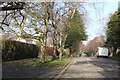
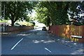
4
The Balgarth
A long-established and busy hotel in Doonfoot, beside the A719 coast road on the south side of Ayr.
Image: © Mary and Angus Hogg
Taken: 11 Nov 2007
0.12 miles
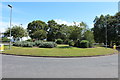
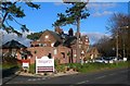
7
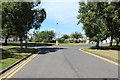
Roundabout on Earls Way, Doonfoot
With Abbots Way.
Image: © Billy McCrorie
Taken: 28 Jul 2014
0.14 miles