IMAGES TAKEN NEAR TO
Dalton Park, AYR, KA7 4GZ
Introduction
This page details the photographs taken nearby to Dalton Park, KA7 4GZ by members of the Geograph project.
The Geograph project started in 2005 with the aim of publishing, organising and preserving representative images for every square kilometre of Great Britain, Ireland and the Isle of Man.

There are currently over 7.5m images from over14,400 individuals and you can help contribute to the project by visiting https://www.geograph.org.uk
Image Map
Images are licensed for reuse under creativecommons.org/licenses/by-sa/2.0
Notes
- Clicking on the map will re-center to the selected point.
- The higher the marker number, the further away the image location is from the centre of the postcode.
Image Listing (38 Images Found)
Images are licensed for reuse under creativecommons.org/licenses/by-sa/2.0
Image
Details
Distance
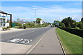
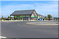
1
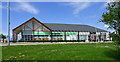
Doonfoot Co-op Store
This new Co-operative serves a growing residential area on the edge of Ayr at Doonfoot.
Image: © Mary and Angus Hogg
Taken: 28 May 2016
0.08 miles
3
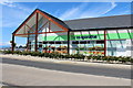
The Co-operative Food Store
Not yet on the map.
Image: © Billy McCrorie
Taken: 28 Jul 2014
0.08 miles
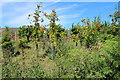
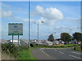
5
The Dunure Road
Approaching the very edge of Alloway.
Image: © Malcolm Neal
Taken: 8 Apr 2019
0.08 miles

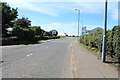
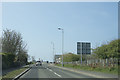
7
Welcome to Ayr
Entering Ayr on the A719 coast road from Dunure, where much new building has taken place recently.
Image: © Mary and Angus Hogg
Taken: 22 Sep 2006
0.08 miles
9
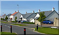
Cumbrae Drive
Part of the new housing development at Greenan Views, on the edge of Ayr.
Image: © Mary and Angus Hogg
Taken: 28 May 2016
0.09 miles
10
The Co-operative Food Store
Not yet on the map.
Image: © Billy McCrorie
Taken: 28 Jul 2014
0.09 miles