IMAGES TAKEN NEAR TO
Arrol Park, KA7 4FF
Introduction
This page details the photographs taken nearby to Arrol Park, KA7 4FF by members of the Geograph project.
The Geograph project started in 2005 with the aim of publishing, organising and preserving representative images for every square kilometre of Great Britain, Ireland and the Isle of Man.

There are currently over 7.5m images from over14,400 individuals and you can help contribute to the project by visiting https://www.geograph.org.uk
Image Map
Images are licensed for reuse under creativecommons.org/licenses/by-sa/2.0
Notes
- Clicking on the map will re-center to the selected point.
- The higher the marker number, the further away the image location is from the centre of the postcode.
Image Listing (89 Images Found)
Images are licensed for reuse under creativecommons.org/licenses/by-sa/2.0
Image
Details
Distance
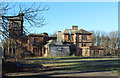
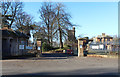
2
Former hospital in Ayr
On Racecourse Road.
Image: © Stephen Sweeney
Taken: 15 Aug 2010
0.02 miles
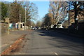
3
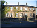
Old Racecourse Pavilion
A view looking east across the A719 to the Old Racecourse Pavilion.
Image: © Phil Williams
Taken: 24 May 2006
0.04 miles
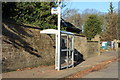
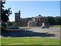
9
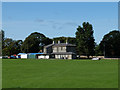
The Old Racecourse
The former horse racing course at Ayr, now used as an area of playing fields.
The building is the former racecourse pavilion.
Image: © John Allan
Taken: 5 Sep 2015
0.08 miles
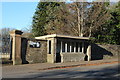
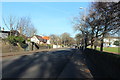
10
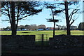
Old Turnstile, Seafield Golf Course
Image: © Billy McCrorie
Taken: 21 Jan 2017
0.08 miles