IMAGES TAKEN NEAR TO
Doonbank Park, AYR, KA7 4EA
Introduction
This page details the photographs taken nearby to Doonbank Park, KA7 4EA by members of the Geograph project.
The Geograph project started in 2005 with the aim of publishing, organising and preserving representative images for every square kilometre of Great Britain, Ireland and the Isle of Man.

There are currently over 7.5m images from over14,400 individuals and you can help contribute to the project by visiting https://www.geograph.org.uk
Image Map
Images are licensed for reuse under creativecommons.org/licenses/by-sa/2.0
Notes
- Clicking on the map will re-center to the selected point.
- The higher the marker number, the further away the image location is from the centre of the postcode.
Image Listing (482 Images Found)
Images are licensed for reuse under creativecommons.org/licenses/by-sa/2.0
Image
Details
Distance
1
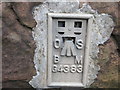
Ordnance Survey Flush Bracket G4383
This can be found on the parapet of the road bridge over a former railway line.
For more detail see : http://www.bench-marks.org.uk/bm11259
Image: © Peter Wood
Taken: 25 Sep 2013
0.04 miles
2
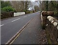
Old railway bridge on Longhill Avenue
Loop of Ayr Coastal Path passes underneath
Image: © Jim Smillie
Taken: 16 Feb 2023
0.04 miles
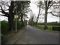
3
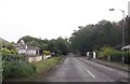
Longhill Avenue straight section
From Doonbank Park
Image: © John Firth
Taken: 15 May 2014
0.04 miles
4
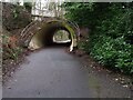
Ayr Coastal Path: Inland loop
Probably to allow access to Robert Burns attractions
Image: © Jim Smillie
Taken: 16 Feb 2023
0.04 miles
5
Railway Bridge
The Line became disused during the Sixties
Just before the bridge there is a tunnel
The Branch Line carried Holiday makers to Butlins down the coast.
The viewpoint was the new Road Bridge across the Doon near Burns Monument.
Image: © Hamish Kirkpatrick
Taken: Unknown
0.08 miles
6
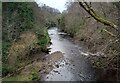
River Doon
Seen from path on old rail line
Image: © Jim Smillie
Taken: 16 Feb 2023
0.10 miles
8
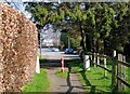
Into Shanter Way
On the very edge of the square. The first house on the right, where the blue car is parked is called Mungo's Well. This name features in Burns's famous poem, Tam O'Shanter. When Tam was riding in the dark towards Alloway Kirk, he passed some grisly spots - "And near the thorn, aboon the well, Whare Mungo's mither hang'd hersel."
Image: © Mary and Angus Hogg
Taken: 18 Mar 2009
0.11 miles
9
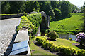
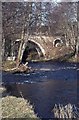
The Brig O'Doon
This ancient footbridge still has its cobbles and thankfully all traffic is banned from crossing it and to make sure there are bollards to stop the traffic.
Image: © Malcolm Neal
Taken: 31 May 2023
0.11 miles
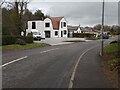
10
Longhill Avenue
Taken from the junction at the Culroy Road.
Image: © Billy McCrorie
Taken: 24 Apr 2012
0.12 miles