IMAGES TAKEN NEAR TO
Doonfoot Road, AYR, KA7 4DW
Introduction
This page details the photographs taken nearby to Doonfoot Road, KA7 4DW by members of the Geograph project.
The Geograph project started in 2005 with the aim of publishing, organising and preserving representative images for every square kilometre of Great Britain, Ireland and the Isle of Man.

There are currently over 7.5m images from over14,400 individuals and you can help contribute to the project by visiting https://www.geograph.org.uk
Image Map
Images are licensed for reuse under creativecommons.org/licenses/by-sa/2.0
Notes
- Clicking on the map will re-center to the selected point.
- The higher the marker number, the further away the image location is from the centre of the postcode.
Image Listing (77 Images Found)
Images are licensed for reuse under creativecommons.org/licenses/by-sa/2.0
Image
Details
Distance
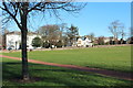
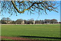
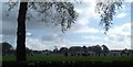
1
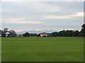
By Racecourse View at the Old Racecourse
A view from the playing fields at the Old Racecourse in Seafield, Ayr. Goat Fell on Arran is in the distance.
Image: © David Hamilton
Taken: 6 Jul 2012
0.02 miles
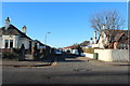
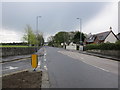
8
Doonfoot Road
Showing slip road from Racecourse view on to Doonfoot Road.
Image: © Billy McCrorie
Taken: 24 Apr 2012
0.05 miles
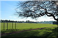
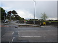
10
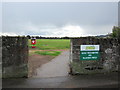
Old Racecourse Playing Fields
Entrance from the junction of Racecourse View and Doonfoot Road.
Image: © Billy McCrorie
Taken: 24 Apr 2012
0.05 miles