IMAGES TAKEN NEAR TO
Cunning Park Drive, AYR, KA7 4DT
Introduction
This page details the photographs taken nearby to Cunning Park Drive, KA7 4DT by members of the Geograph project.
The Geograph project started in 2005 with the aim of publishing, organising and preserving representative images for every square kilometre of Great Britain, Ireland and the Isle of Man.

There are currently over 7.5m images from over14,400 individuals and you can help contribute to the project by visiting https://www.geograph.org.uk
Image Map
Images are licensed for reuse under creativecommons.org/licenses/by-sa/2.0
Notes
- Clicking on the map will re-center to the selected point.
- The higher the marker number, the further away the image location is from the centre of the postcode.
Image Listing (95 Images Found)
Images are licensed for reuse under creativecommons.org/licenses/by-sa/2.0
Image
Details
Distance
2
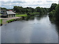
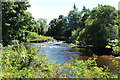
River Doon
Looking up the River Doon from the Millennium Bridge. The river is about to enter the Firth of Clyde on the opposite side of the bridge from the direction of this photograph.
Image: © G Laird
Taken: 24 Aug 2008
0.05 miles
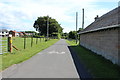
5
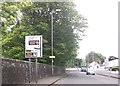
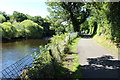
Ayrshire Coastal Path Detour to Burn's Cottage
Image: © Billy McCrorie
Taken: 28 Jul 2014
0.08 miles
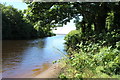
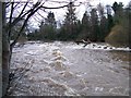
6
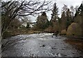
River Doon
Narrowing channel causing more rapid flow
Image: © Jim Smillie
Taken: 16 Feb 2023
0.09 miles
8
The River Doon flowing over the weir
Image: © Elliott Simpson
Taken: 26 Jan 2014
0.11 miles
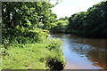
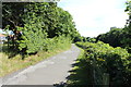
9
Ayrshire Coastal Path Detour to Burn's Cottage
Image: © Billy McCrorie
Taken: 28 Jul 2014
0.11 miles