IMAGES TAKEN NEAR TO
Doonfoot Road, AYR, KA7 4DP
Introduction
This page details the photographs taken nearby to Doonfoot Road, KA7 4DP by members of the Geograph project.
The Geograph project started in 2005 with the aim of publishing, organising and preserving representative images for every square kilometre of Great Britain, Ireland and the Isle of Man.

There are currently over 7.5m images from over14,400 individuals and you can help contribute to the project by visiting https://www.geograph.org.uk
Image Map
Images are licensed for reuse under creativecommons.org/licenses/by-sa/2.0
Notes
- Clicking on the map will re-center to the selected point.
- The higher the marker number, the further away the image location is from the centre of the postcode.
Image Listing (156 Images Found)
Images are licensed for reuse under creativecommons.org/licenses/by-sa/2.0
Image
Details
Distance
2
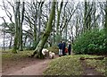
New Year's Walk
Several people were enjoying a New Year walk with the dogs in Ayr's Belleisle Park on 1 January. The weather forecast was accurate, with skies darkening and rain approaching fast.
Image: © Mary and Angus Hogg
Taken: 1 Jan 2014
0.09 miles
5
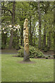
Another carved tree
Presumably this tree stump is all that remains of a dead or dying tree and has been carved into this garden ornament.
Image: © Malcolm Neal
Taken: 9 May 2018
0.10 miles
7
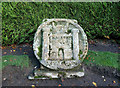
The Coat of Arms for Ayr
The Coat of Arms for the Royal Burgh of Ayr is the 3-towered Royal Castle of the town. It was located on the site that was used by Cromwell for his fort, to the south of the harbour. This one is in the grounds of Belleisle. There's another nearby Image and one on the Wallace Tower in the High Street Image
Image: © Mary and Angus Hogg
Taken: 20 Nov 2013
0.11 miles