IMAGES TAKEN NEAR TO
Longhill Avenue, AYR, KA7 4DF
Introduction
This page details the photographs taken nearby to Longhill Avenue, KA7 4DF by members of the Geograph project.
The Geograph project started in 2005 with the aim of publishing, organising and preserving representative images for every square kilometre of Great Britain, Ireland and the Isle of Man.

There are currently over 7.5m images from over14,400 individuals and you can help contribute to the project by visiting https://www.geograph.org.uk
Image Map
Images are licensed for reuse under creativecommons.org/licenses/by-sa/2.0
Notes
- Clicking on the map will re-center to the selected point.
- The higher the marker number, the further away the image location is from the centre of the postcode.
Image Listing (22 Images Found)
Images are licensed for reuse under creativecommons.org/licenses/by-sa/2.0
Image
Details
Distance
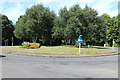
1
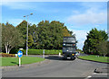
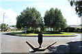
Longhill Avenue Roundabout
The junction of Longhill Avenue, Ayr and the A719 to Dunure, showing the bus leaving for Craig Tara Holiday Park (formerly Butlin's)
Image: © Mary and Angus Hogg
Taken: 22 Sep 2006
0.01 miles
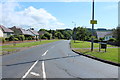
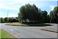
3
Roundabout at Earls Way, Doonfoot
From Longhill Avenue.
Image: © Billy McCrorie
Taken: 28 Jul 2014
0.06 miles
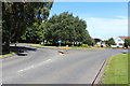
7
Roundabout at Earls Way, Doonfoot
From Earls Way.
Image: © Billy McCrorie
Taken: 28 Jul 2014
0.08 miles
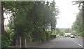
8
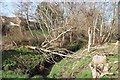
A burn close to the Doon
An un-named tributary of the River Doon.
Image: © Alan Reid
Taken: 26 Feb 2019
0.08 miles