IMAGES TAKEN NEAR TO
Glenalla Crescent, AYR, KA7 4DA
Introduction
This page details the photographs taken nearby to Glenalla Crescent, KA7 4DA by members of the Geograph project.
The Geograph project started in 2005 with the aim of publishing, organising and preserving representative images for every square kilometre of Great Britain, Ireland and the Isle of Man.

There are currently over 7.5m images from over14,400 individuals and you can help contribute to the project by visiting https://www.geograph.org.uk
Image Map
Images are licensed for reuse under creativecommons.org/licenses/by-sa/2.0
Notes
- Clicking on the map will re-center to the selected point.
- The higher the marker number, the further away the image location is from the centre of the postcode.
Image Listing (15 Images Found)
Images are licensed for reuse under creativecommons.org/licenses/by-sa/2.0
Image
Details
Distance
1
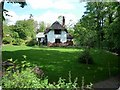
Doonbank Cottage
Self catering thatched holiday cottage
Image: © Chris Swaine
Taken: 18 Jun 2009
0.12 miles
2
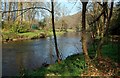
River Doon
Looking downstream from the riverside path coming from Alloway on a fine March day.
Image: © Mary and Angus Hogg
Taken: 18 Mar 2009
0.14 miles
3
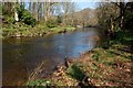
Ye Banks And Braes O' Bonnie Doon
The River Doon at Alloway, immortalised in Burns's famous song. Looking downstream from the riverside path on a fine March day.
Image: © Mary and Angus Hogg
Taken: 18 Mar 2009
0.15 miles
4
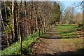
Riverside Path
A popular footpath in Alloway. The River Doon is on the left-hand side of the photo. Viewed on a fine March day.
Image: © Mary and Angus Hogg
Taken: 18 Mar 2009
0.17 miles
5
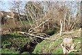
A burn close to the Doon
An un-named tributary of the River Doon.
Image: © Alan Reid
Taken: 26 Feb 2019
0.19 miles
6
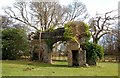
Remains of Cambusdoon House
This old arch is all that remains of Cambusdoon House, the home of the 19th century steel tycoon, James Baird. The building was burned down in 1970. (Source: "Ayrshire: Discovering A County", by Dane Love).
Image: © Mary and Angus Hogg
Taken: 25 Feb 2009
0.20 miles
7
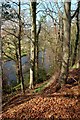
Above The River Doon
Looking downstream from the high banking in Alloway. This view can be seen only when the foliage is absent from the trees.
Image: © Mary and Angus Hogg
Taken: 18 Mar 2009
0.21 miles
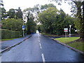
9
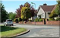
Portmark Avenue
The Explorer map confirms the location just inside the square. Located in Doonfoot, an affluent and attractive part of Ayr.
Image: © Mary and Angus Hogg
Taken: 20 May 2009
0.22 miles
10
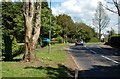
Longhill Avenue.
In an earlier photo, Image, I thought that the trees were heavily pollarded. This up-to-date photos shows that they were being prepared for felling. Compared with the December 2006 photo, two trees are now missing from this view.
Image: © Mary and Angus Hogg
Taken: 20 May 2009
0.24 miles