IMAGES TAKEN NEAR TO
Davaar Crescent, AYR, KA7 4BS
Introduction
This page details the photographs taken nearby to Davaar Crescent, KA7 4BS by members of the Geograph project.
The Geograph project started in 2005 with the aim of publishing, organising and preserving representative images for every square kilometre of Great Britain, Ireland and the Isle of Man.

There are currently over 7.5m images from over14,400 individuals and you can help contribute to the project by visiting https://www.geograph.org.uk
Image Map
Images are licensed for reuse under creativecommons.org/licenses/by-sa/2.0
Notes
- Clicking on the map will re-center to the selected point.
- The higher the marker number, the further away the image location is from the centre of the postcode.
Image Listing (35 Images Found)
Images are licensed for reuse under creativecommons.org/licenses/by-sa/2.0
Image
Details
Distance
7
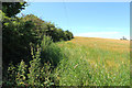
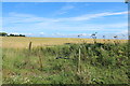
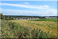
Farmland at Greenan
On the far right is Greenan Castle.
Image: © Billy McCrorie
Taken: 28 Jul 2014
0.16 miles
8
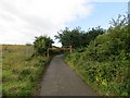
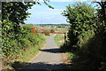
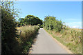
Road, Greenan
A narrow road which gives access to Greenan Castle. The tar stops at the top of the hill.
Image: © Richard Webb
Taken: 13 Aug 2014
0.16 miles