IMAGES TAKEN NEAR TO
Arrol Drive, AYR, KA7 4AG
Introduction
This page details the photographs taken nearby to Arrol Drive, KA7 4AG by members of the Geograph project.
The Geograph project started in 2005 with the aim of publishing, organising and preserving representative images for every square kilometre of Great Britain, Ireland and the Isle of Man.

There are currently over 7.5m images from over14,400 individuals and you can help contribute to the project by visiting https://www.geograph.org.uk
Image Map (Loading...)


Getting Data...Please wait
Leaflet Map data © OpenStreetMap
Images are licensed for reuse under creativecommons.org/licenses/by-sa/2.0
Notes
- Clicking on the map will re-center to the selected point.
- The higher the marker number, the further away the image location is from the centre of the postcode.
Image Listing (104 Images Found)
Images are licensed for reuse under creativecommons.org/licenses/by-sa/2.0
Image
Details
Distance
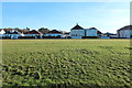
1
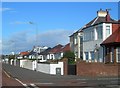
Seafield Drive
Attractive houses with a fine view, looking out across open green space towards the Firth of Clyde.
Image: © Mary and Angus Hogg
Taken: 17 Oct 2007
0.07 miles
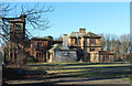
3
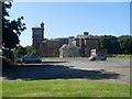
Former hospital in Ayr
On Racecourse Road.
Image: © Stephen Sweeney
Taken: 15 Aug 2010
0.09 miles
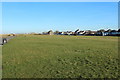
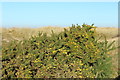
5
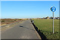
Esplanade, Seafield
Behind the dunes, a road open only to non motorised traffic.
Image: © Richard Webb
Taken: 13 Aug 2014
0.10 miles
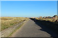
9
Promenade at Seafield
Also part of the Ayrshire Coastal Path.
Image: © Billy McCrorie
Taken: 21 Jan 2017
0.11 miles
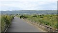
10
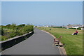
The path along the seafront
On a hot afternoon the walk along the seafront was very pleasant.
Image: © Malcolm Neal
Taken: 31 May 2023
0.11 miles