IMAGES TAKEN NEAR TO
Poppy Bank Terrace, AYR, KA7 3ZA
Introduction
This page details the photographs taken nearby to Poppy Bank Terrace, KA7 3ZA by members of the Geograph project.
The Geograph project started in 2005 with the aim of publishing, organising and preserving representative images for every square kilometre of Great Britain, Ireland and the Isle of Man.

There are currently over 7.5m images from over14,400 individuals and you can help contribute to the project by visiting https://www.geograph.org.uk
Image Map
Images are licensed for reuse under creativecommons.org/licenses/by-sa/2.0
Notes
- Clicking on the map will re-center to the selected point.
- The higher the marker number, the further away the image location is from the centre of the postcode.
Image Listing (16 Images Found)
Images are licensed for reuse under creativecommons.org/licenses/by-sa/2.0
Image
Details
Distance
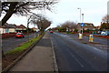
1
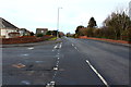
Kincaidston Drive
The photo shows the main road round this area of Council housing at the edge of Ayr.
Image: © Mary and Angus Hogg
Taken: 21 Jun 2007
0.15 miles
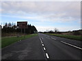
2
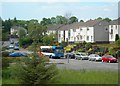
Ayr, Kincaidston
From the A77 By-pass.
Image: © Billy McCrorie
Taken: 4 Jan 2013
0.16 miles
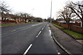
3
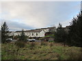
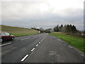
A dull day on the A77
Though just after midday the outlook along the road is very dark.
Image: © Malcolm Neal
Taken: 22 Sep 2022
0.17 miles
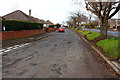
4
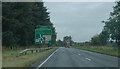
Ayr By-Pass
Near Kincaidston in the direction of Maybole.
Image: © Billy McCrorie
Taken: 4 Jan 2013
0.18 miles