IMAGES TAKEN NEAR TO
Hawthorn Drive, AYR, KA7 3TB
Introduction
This page details the photographs taken nearby to Hawthorn Drive, KA7 3TB by members of the Geograph project.
The Geograph project started in 2005 with the aim of publishing, organising and preserving representative images for every square kilometre of Great Britain, Ireland and the Isle of Man.

There are currently over 7.5m images from over14,400 individuals and you can help contribute to the project by visiting https://www.geograph.org.uk
Image Map
Images are licensed for reuse under creativecommons.org/licenses/by-sa/2.0
Notes
- Clicking on the map will re-center to the selected point.
- The higher the marker number, the further away the image location is from the centre of the postcode.
Image Listing (15 Images Found)
Images are licensed for reuse under creativecommons.org/licenses/by-sa/2.0
Image
Details
Distance
1

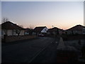
Briar Grove
Taken just before dusk on New Year's Day.
Image: © Norman Brown
Taken: 1 Jan 2009
0.08 miles
2
Briar Grove
Taken just before dusk on New Year's Day
Image: © Norman Brown
Taken: 1 Jan 2009
0.14 miles
3

Junction, Burnbank Road and Dalmellington Road
Image: © Alan Reid
Taken: 26 Feb 2019
0.14 miles
4
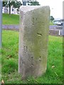
Old Milestone by the A713, 148 Dalmellington Road, Ayr
Ayr granite in parish of Ayr (Carrick District), 148 Dalmellington Road, outside Bankfield Medical Centre.
Inscription reads:-
: Ayr / 2 : : Patna / 8 / Dalmellington / 13¼ :
Surveyed
Milestone Society National ID: AYS_AYDL02
Image: © Milestone Society
Taken: Unknown
0.18 miles
5

Woodland Walk
A woodland walk in Castlehill Park, Ayr. This small woodland is surrounded by housing.
Image: © Mary and Angus Hogg
Taken: 24 Jan 2008
0.18 miles
6

Building The New Queen Margaret Academy
Major work is under way to develop the new school complex on Ayr's Dalmellington Road.
Image: © Mary and Angus Hogg
Taken: 10 Oct 2018
0.21 miles
7

The new Queen Margaret Academy building
Viewed during the January 2021 lockdown, the new building opened in October 2019. Demolition of the old building was well under way by then. For a view of the site under construction and for more information, see Image
Image: © Mary and Angus Hogg
Taken: 25 Jan 2021
0.21 miles
8

Castlehill Park
Children's play area in Castlehill Park, operated by South Ayrshire Council.
Image: © Mary and Angus Hogg
Taken: 24 Jan 2008
0.22 miles

10
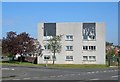
Flats at Kincaidston
Flats in Stonecrop Place, Kincaidston, on the edge of Ayr.
Image: © Mary and Angus Hogg
Taken: 4 May 2007
0.23 miles